IMAGES TAKEN NEAR TO
Coventry Road, WARWICK, CV34 5HL
Introduction
This page details the photographs taken nearby to Coventry Road, CV34 5HL by members of the Geograph project.
The Geograph project started in 2005 with the aim of publishing, organising and preserving representative images for every square kilometre of Great Britain, Ireland and the Isle of Man.

There are currently over 7.5m images from over14,400 individuals and you can help contribute to the project by visiting https://www.geograph.org.uk
Image Map
Images are licensed for reuse under creativecommons.org/licenses/by-sa/2.0
Notes
- Clicking on the map will re-center to the selected point.
- The higher the marker number, the further away the image location is from the centre of the postcode.
Image Listing (230 Images Found)
Images are licensed for reuse under creativecommons.org/licenses/by-sa/2.0
Image
Details
Distance
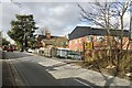
1
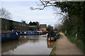
Kate Boats, Grand Union Canal
Right at the edge of the square, Kate Boats is a repair yard and overnight stop on the Grand Union Canal in Warwick. The bridge in the distance is Coventry Road.
Image: © Geoff Gartside
Taken: 11 Mar 2007
0.02 miles
2
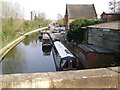
Grand Union Canal at Coventry Road, Warwick
Preparations for the 2009 boating season at Kate Boats.
Image: © Robin Stott
Taken: 3 Apr 2009
0.02 miles
3
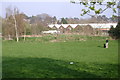
De facto open space off Coventry Road, Warwick
Local people are making informal use of this undeveloped land behind the County Council depot in Montague Road Image
Image: © Robin Stott
Taken: 3 Apr 2009
0.02 miles
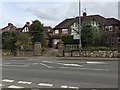
4
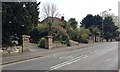
Garden walls and gate pillars, Cliff Hill, Coventry Road, Warwick
A map of 1938 shows this row of semi-detached houses in outline. There had formerly been a large villa here called Guy's Cross Hill, at the summit of Cliff Hill. It is not known what or where Guy's Cross is or was. Speculating: a boundary marker with the Guy's Cliffe estate?
Image: © Robin Stott
Taken: 9 Apr 2019
0.02 miles
5
Northwest end of Nelson Lane, Warwick
Looking towards the junction with Coventry Road, left. The building on the right is the roadside part of Kate Boats. They have a fleet of cruising canal boats and are clearly preparing to provide canal-based staycations through 2021 following the worst of the Covid-19 pandemic. The house left of centre is Bridge House, seen from the front in Image The Nelson name refers to the family whose factory by the canal manufactured gelatines.
Image: © Robin Stott
Taken: 12 Feb 2021
0.02 miles
6
The summit of Cliff Hill, Coventry Road, Warwick
A map of 1938 shows this row of semi-detached houses in outline. Image is a view from 2009. There had formerly been a large villa here called Guy's Cross Hill, at the summit of Cliff Hill. It is not known what or where Guy's Cross is or was. Speculating: a boundary marker with the Guy's Cliffe estate?
Image: © Robin Stott
Taken: 9 Apr 2019
0.03 miles
7
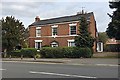
Bridge House, 146 Coventry Road, Warwick
Built around 1780, listed Grade II https://historicengland.org.uk/listing/the-list/list-entry/1184344
Image: © Robin Stott
Taken: 9 Apr 2019
0.04 miles
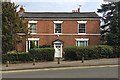
8
![Warwick houses [157]](https://s3.geograph.org.uk/geophotos/06/63/01/6630175_3bf7456d_120x120.jpg)
Warwick houses [157]
Bridge House, number 146 Coventry Road, is late 18th century with a symmetrical facade in red brick. Listed, grade II, with details at: https://historicengland.org.uk/listing/the-list/list-entry/1184344
A market town and county town of Warwickshire, Warwick lies on the River Avon, 11 miles (18 kilometres) south of Coventry. There is evidence of unbroken habitation from the 6th century AD with signs of Neolithic and Roman activity before that date. It was a Saxon burh in the 9th century and Warwick Castle was built during the Norman Conquest. Much of the town was destroyed in The Great Fire of Warwick in 1694. Warwick Racecourse is located just west of the town centre. The Grand Union Canal passes through the town and the restored Saltisford Canal Arm is close to the town centre.
Image: © Michael Dibb
Taken: 4 Aug 2020
0.04 miles
9
Bridge House, 146 Coventry Road, Warwick
Late eighteenth century, listed Grade II https://historicengland.org.uk/listing/the-list/list-entry/1184344
Image: © Robin Stott
Taken: 9 Apr 2019
0.04 miles
10
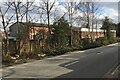
Works and offices, Nelson Lane, Warwick
The building at the back is believed to be a canal-based business: the Grand Union Canal runs past it. The building on Nelson Lane, partly offices, may or may not be related. Research needed.
Image: © Robin Stott
Taken: 12 Feb 2021
0.05 miles