IMAGES TAKEN NEAR TO
Lower Cape, WARWICK, CV34 5DR
Introduction
This page details the photographs taken nearby to Lower Cape, CV34 5DR by members of the Geograph project.
The Geograph project started in 2005 with the aim of publishing, organising and preserving representative images for every square kilometre of Great Britain, Ireland and the Isle of Man.

There are currently over 7.5m images from over14,400 individuals and you can help contribute to the project by visiting https://www.geograph.org.uk
Image Map
Images are licensed for reuse under creativecommons.org/licenses/by-sa/2.0
Notes
- Clicking on the map will re-center to the selected point.
- The higher the marker number, the further away the image location is from the centre of the postcode.
Image Listing (123 Images Found)
Images are licensed for reuse under creativecommons.org/licenses/by-sa/2.0
Image
Details
Distance
1
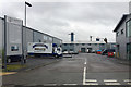
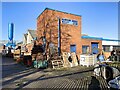
St George's Industrial Park, Lower Cape, Warwick
Lower Cape once had heavy industry: all gone. This is a small industrial estate among extensive new housing whose selling points include being near the canal.
Image: © Robin Stott
Taken: 29 Mar 2017
0.02 miles
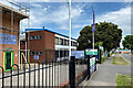
3
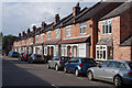
Industry, north side of Millers Road, Warwick
The premises on the right are occupied by Thomas Sanderson, suppliers of bespoke window furnishings: fitted curtains, blinds, awnings and shutters. The south side of the road is residential.
Image: © Robin Stott
Taken: 25 Mar 2019
0.05 miles
4
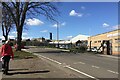
Lower Cape, Warwick
This road leads down to the Cape of Good Hope pub and the Grand Union Canal. It is lined with terraced houses.
Image: © Stephen McKay
Taken: 4 Aug 2021
0.06 miles
5
Aluminium castings works, Millers Road, Warwick
Part of the Aluminium Service Company's premises https://www.aluminiumservice.co.uk/index.php
Image: © Robin Stott
Taken: 9 Jan 2022
0.06 miles
7
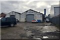
Falcon workshops, Lock Lane, Warwick
Falcon is an established company that does things to cars.
Image: © Robin Stott
Taken: 16 Jan 2021
0.07 miles
8
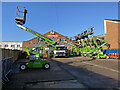
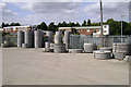
Access platforms, Plantool hire centre, Millers Road, Warwick
Towable and tracked models.
Image: © Robin Stott
Taken: 9 Jan 2022
0.07 miles
9
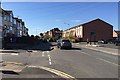
Northwest on Cape Road, the Cape, Warwick
Cape Road appears to have been a route from Warwick Castle to its northern deer park at Wedgnock. Today it is a busy suburban road connecting mixed housing, assorted businesses, a few shops, allotments, GP practices and a secure mental hospital. The view is from the corner of Hanworth Road.
Image: © Robin Stott
Taken: 10 Apr 2019
0.07 miles
10
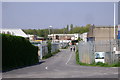
Lock Lane, Warwick
For many years an unadopted road into a trading estate off Millers Road, but here looking semi-adopted.
Leads to a footbridge over the Grand Union Canal, just below Cape Bottom Lock.
Image: © Robin Stott
Taken: 20 Apr 2009
0.08 miles