IMAGES TAKEN NEAR TO
Lakin Road, WARWICK, CV34 5BL
Introduction
This page details the photographs taken nearby to Lakin Road, CV34 5BL by members of the Geograph project.
The Geograph project started in 2005 with the aim of publishing, organising and preserving representative images for every square kilometre of Great Britain, Ireland and the Isle of Man.

There are currently over 7.5m images from over14,400 individuals and you can help contribute to the project by visiting https://www.geograph.org.uk
Image Map
Images are licensed for reuse under creativecommons.org/licenses/by-sa/2.0
Notes
- Clicking on the map will re-center to the selected point.
- The higher the marker number, the further away the image location is from the centre of the postcode.
Image Listing (323 Images Found)
Images are licensed for reuse under creativecommons.org/licenses/by-sa/2.0
Image
Details
Distance
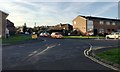
1
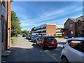
Northwest on Lakin Road, Warwick
In the sun is the end wall of the flats in Remburn Gardens, photographed from outside the convenience store on the corner of Paradise Street Image (no longer a Spar). This view is the reverse of Image
Image: © Robin Stott
Taken: 15 Jun 2022
0.02 miles
2

Warwick Hospital Path Lab, Lakin Road
Pathology Laboratory, brown brick, centre.
It is quite common to see trolleys of different shapes, sizes and contents being trundled about the streets.
Image: © Robin Stott
Taken: 14 Apr 2009
0.02 miles

4
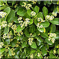
Japanese Spindletree in flower, Warwick
Euonymus japonicus, its scientific name, was a popular evergreen hedging plant in the days when people burned coal. Soot deposited on the glossy, leathery leaves was readily washed off by rain. It is salt-tolerant for the same reason, and is reported to be naturalized on sea cliffs. It's a good plant – it's dense and more manageable than some hedging plants and the flowers are succeeded by bright orange berries in autumn. Will it go native as the climate warms?
Image: © Robin Stott
Taken: 28 Jul 2022
0.02 miles
5
Lakin Court, Warwick
Catching early afternoon sun on a Boxing Day leg-stretch.
Image: © Robin Stott
Taken: 26 Dec 2013
0.03 miles
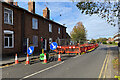
6
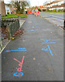
Map of underground services, Lakin Road, Warwick
Gas supply pipes were being renewed.
Image: © Robin Stott
Taken: 21 Nov 2021
0.03 miles
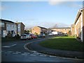
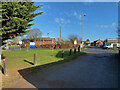
7
Junction of Vine Lane and Lakin Court, Packmores, Warwick
Vine Lane ahead and Lakin Court, right, are seen from the west end of Paradise Street. The name Packmores goes back centuries; it's remembered in parallel Packmores Street. A map of 1887 shows greenhouses: could they have been for a vine? Is Vine Lane related, or did it take its name from The Vine public house, now replaced by houses? It's all surmise – there is no decent history of the modern town though plenty has been written about the historic centre, the Castle and the Castle Park.
Image: © Robin Stott
Taken: 26 Nov 2016
0.04 miles
8
Replacing gas supply pipes, Lakin Road, Warwick
Image: © Robin Stott
Taken: 4 Nov 2021
0.04 miles
9
Green Lane meets Lakin Road, Warwick
Green Lane is an unadopted residential road with a boundary to Warwick Hospital. The hospital pharmacy is seen In the left background.
Image: © Robin Stott
Taken: 16 Jan 2022
0.04 miles
10
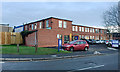
Warwick Hospital Pathology Laboratory, Lakin Road, Warwick
The thaw is almost complete: a few stubborn piles of snow remain.
Image: © Robin Stott
Taken: 14 Dec 2017
0.04 miles