IMAGES TAKEN NEAR TO
Yeomanry Close, WARWICK, CV34 4UT
Introduction
This page details the photographs taken nearby to Yeomanry Close, CV34 4UT by members of the Geograph project.
The Geograph project started in 2005 with the aim of publishing, organising and preserving representative images for every square kilometre of Great Britain, Ireland and the Isle of Man.

There are currently over 7.5m images from over14,400 individuals and you can help contribute to the project by visiting https://www.geograph.org.uk
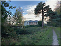
Image Map
Images are licensed for reuse under creativecommons.org/licenses/by-sa/2.0
Notes
- Clicking on the map will re-center to the selected point.
- The higher the marker number, the further away the image location is from the centre of the postcode.
Image Listing (812 Images Found)
Images are licensed for reuse under creativecommons.org/licenses/by-sa/2.0
Image
Details
Distance
1
View of Park View, Warwick
Park View, a care home in Priory Road, lives up to its name here overlooking the edge of Priory Park.
Image: © Robin Stott
Taken: 6 Nov 2022
0.03 miles
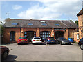
2
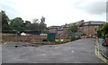
Site of Park View care home, off Priory Road, Warwick
Runwood Homes will be rebuilding their Park View care home http://www.runwoodhomes.co.uk/product.php/63/park_view_warwickshire The range of sheltered accommodation in Yeomanry Close, right, is owned and managed by Warwick District Council http://www.housingcare.org/housing-care/facility-info-36286-yeomanry-close-priory-road-england.aspx
Update 2017: Image
Image: © Robin Stott
Taken: 19 Jul 2014
0.03 miles
3
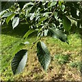
Leaves and buds of Raoul, Warwick
Raoul or Rauli is the common name of a species of Southern Beech, Nothofagus procera. It was introduced to Britain from Chile in 1913. The leaves are perhaps 4-8 cm long, from the tree photographed in November 2022 Image The buds are next season's flower buds.
Photo number 6718173.
Image: © Robin Stott
Taken: 6 Oct 2023
0.03 miles
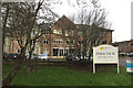
4
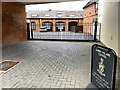
Sorry, Museum closed, Priory Road, Warwick
Offices in a former drill hall Image have become The Museum of the Queen's Royal Hussars (Churchill's own regiment).
Image: © Robin Stott
Taken: 8 Sep 2022
0.04 miles
5
Former First World War Drill Hall, rear of Priory Road, Warwick
Although a substantial former house fronting Priory Road, behind and to the right of the camera, calls itself 'The Old Drill Hall', this building to the north of it looks more like a drill hall. People working in the building certainly believed that it had been. It first appears on OS 1:2500 County Series maps dated 1913-27. It seems reasonable to surmise that it was built around the start of World War I. Its current address is No.2 Trinity Mews, Priory Road, Warwick CV34 4NA, and is home to a couple of businesses. A first floor has been inserted – the reason for the rooflights. Nothing else is known at the time of writing (July 2014). Earlier maps show a group of buildings around a courtyard garden with a fountain at its centre and glasshouses on its north side.
Don Funnell writes, 10 Jan 2016: "yes it was a drill hall at least until the 1960s. My father was a military person there in the 1950s. There was even a .22 rifle range on the site."
Update: September 2022. The property has opened as the Museum of the Queen's Royal Hussars (Churchill's own regiment) Image
Image: © Robin Stott
Taken: 30 Jul 2014
0.04 miles
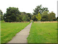
6
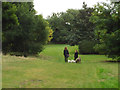
Dog-walking after school, Priory Park, Warwick
This well-used grass path is parallel to the park's southern boundary.
Image: © Robin Stott
Taken: 13 Sep 2013
0.04 miles
7
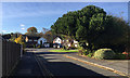
The Paddocks, off Coventry Road, Warwick
The evergreen tree looks like Stone or Umbrella Pine (Pinus pinea).
Image: © Robin Stott
Taken: 8 Nov 2017
0.04 miles
8
New accommodation at Park View, Priory Road, Warwick
A sign by Runwood Homes announces Senior Living at the rebuilt Park View. It's a private residential care home https://www.runwoodhomes.co.uk/homes/park-view-warwickshire The site adjoins Warwick District Council sheltered housing in Yeomanry Close, partly seen on the right and last photographed in July 2014: Image
Image: © Robin Stott
Taken: 23 Dec 2017
0.04 miles
9
Straight tarmac path west, Priory Park, Warwick
It heads straight for the site of Priory House (dismantled in the 1920s) but turns sharply south on approaching a scrub-covered bank which may once have been part of an Iron Age hillfort. The trees in the middle distance were planted in the early 1990s as the first stage of an arboretum.
Image: © Robin Stott
Taken: 13 Sep 2013
0.06 miles
10
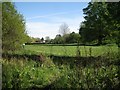
View south across lower Priory Park, Warwick
The long low roof of the Nursery School shows above a hedge, left of centre, with a house in The Paddocks beyond. The woman on the left was walking a husky who was apparently feeling hot in the warm May sunshine. It had drunk from the brook Image
Image: © Robin Stott
Taken: 11 May 2015
0.06 miles