IMAGES TAKEN NEAR TO
Cape Road, WARWICK, CV34 4JP
Introduction
This page details the photographs taken nearby to Cape Road, CV34 4JP by members of the Geograph project.
The Geograph project started in 2005 with the aim of publishing, organising and preserving representative images for every square kilometre of Great Britain, Ireland and the Isle of Man.

There are currently over 7.5m images from over14,400 individuals and you can help contribute to the project by visiting https://www.geograph.org.uk
Image Map
Images are licensed for reuse under creativecommons.org/licenses/by-sa/2.0
Notes
- Clicking on the map will re-center to the selected point.
- The higher the marker number, the further away the image location is from the centre of the postcode.
Image Listing (581 Images Found)
Images are licensed for reuse under creativecommons.org/licenses/by-sa/2.0
Image
Details
Distance
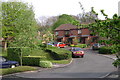
1
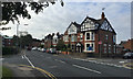
South and uphill on Cape Road, Warwick
The view from north of the bridge over the railway; entry to Spring Pool residential development on the left Image, Cape Road Clinic beyond; Victoria Street on the right Image
Image: © Robin Stott
Taken: 31 Aug 2016
0.01 miles
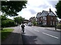
2

Cape Road, Warwick
Looking north along Cape Road towards the railway bridge.
This photo was taken during the no-fly period (15/4/10 – 20/4/10) caused by the eruption of the 1666 metre Icelandic volcano, Mount Eyjafjallajökull. There is no trace of vapour trails across this perfect clear sky.
Image: © David P Howard
Taken: 16 Apr 2010
0.02 miles
3
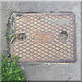
Inspection cover, Cape Road, Warwick
The relief inscription reads DUDLEY & DOWELL / LTD / CRADLEY HEATH / STAFFS. The feature in the corner says DAND, I think – a contraction of D AND D perhaps. Cradley Heath is in the Black Country, B64, around Image
Image: © Robin Stott
Taken: 31 Aug 2016
0.02 miles
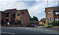
4
West end of Victoria Street, Warwick
Victoria Street runs between Saltisford and Cape Road, foreground, the camera location in SP2865.
Image: © Robin Stott
Taken: 31 Aug 2016
0.02 miles
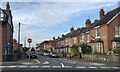
5
Cape Road, Warwick
In a street of mixed uses there is some residential: Spring Pool, fairly recent, left; Victoria Street, Victorian or Edwardian, right. The tower of St Mary's Church is seen on the skyline.
Image: © Robin Stott
Taken: 13 Jul 2009
0.02 miles
6
Spring Pool off Cape Road, Warwick
Electric hedge trimmers bring out the sculptor in some people.
Image: © Robin Stott
Taken: 15 Apr 2009
0.05 miles
7
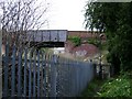
Railway security fence by the footpath, Warwick
The graffiti tag on the bridge (Cape Road, out of square) reads as OAP. Amusing.
Image: © Robin Stott
Taken: 13 Jul 2009
0.06 miles
8
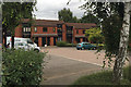
Dwellings, Spring Pool off Cape Road, Warwick
A private development of flats and houses built on allotment land. These dwellings are difficult to read: the left-hand block has three front doors, the one on the left wider than the other two. Could this be two single-person flats and a maisonette or larger flat for a family or disabled person? See also Image
Image: © Robin Stott
Taken: 2 Sep 2016
0.06 miles
10
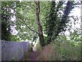
Footpath by the railway, Warwick
Railway, left. Over the hedge, right, are the allotments to the rear of Deer Park Drive and Newburgh Crescent.
Image: © Robin Stott
Taken: 13 Jul 2009
0.07 miles