IMAGES TAKEN NEAR TO
Commainge Close, WARWICK, CV34 4DZ
Introduction
This page details the photographs taken nearby to Commainge Close, CV34 4DZ by members of the Geograph project.
The Geograph project started in 2005 with the aim of publishing, organising and preserving representative images for every square kilometre of Great Britain, Ireland and the Isle of Man.

There are currently over 7.5m images from over14,400 individuals and you can help contribute to the project by visiting https://www.geograph.org.uk
Image Map
Images are licensed for reuse under creativecommons.org/licenses/by-sa/2.0
Notes
- Clicking on the map will re-center to the selected point.
- The higher the marker number, the further away the image location is from the centre of the postcode.
Image Listing (724 Images Found)
Images are licensed for reuse under creativecommons.org/licenses/by-sa/2.0
Image
Details
Distance
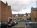
1
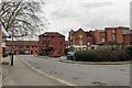
Rear of Saltisford properties, Warwick
Saltisford is an old street, running northwest and downhill from the town centre, becoming the Birmingham Road. The view is from Parkes Street, which was formed as the public access to a large Sainsbury's supermarket, left, and its car park behind the camera..
Image: © Robin Stott
Taken: 22 Feb 2020
0.02 miles
2
The Kings Head Pub, Warwick
Saltisford WARWICK CV34 4TD close to The Saltisford Arm Grand Union Canal
Image: © canalandriversidepubs co uk
Taken: 4 Jun 2010
0.02 miles
3
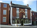
Warwick-The King's Head
Public House In Saltisford dating back 400 years.
Image: © Ian Rob
Taken: 16 Apr 2011
0.02 miles
4
![Warwick buildings [127]](https://s1.geograph.org.uk/geophotos/06/62/81/6628169_96fef2dd_120x120.jpg)
Warwick buildings [127]
The Kings Head public house, number 39 Saltisford, was built in 1806 with a red brick symmetrical facade with stone dressings. The sign bracket is ornamental ironwork and is probably original. Listed, grade II, with details at: https://historicengland.org.uk/listing/the-list/list-entry/1364851
A market town and county town of Warwickshire, Warwick lies on the River Avon, 11 miles (18 kilometres) south of Coventry. There is evidence of unbroken habitation from the 6th century AD with signs of Neolithic and Roman activity before that date. It was a Saxon burh in the 9th century and Warwick Castle was built during the Norman Conquest. Much of the town was destroyed in The Great Fire of Warwick in 1694. Warwick Racecourse is located just west of the town centre. The Grand Union Canal passes through the town and the restored Saltisford Canal Arm is close to the town centre.
Image: © Michael Dibb
Taken: 4 Aug 2020
0.02 miles
5
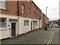
![Warwick houses [155]](https://s0.geograph.org.uk/geophotos/06/62/81/6628168_63701531_120x120.jpg)
Warwick houses [155]
Numbers 33 and 35 Saltisford are two early 19th century houses in red brick. Number 33 retains the original projecting shop front. Listed, grade II, with details at: https://historicengland.org.uk/listing/the-list/list-entry/1035367
A market town and county town of Warwickshire, Warwick lies on the River Avon, 11 miles (18 kilometres) south of Coventry. There is evidence of unbroken habitation from the 6th century AD with signs of Neolithic and Roman activity before that date. It was a Saxon burh in the 9th century and Warwick Castle was built during the Norman Conquest. Much of the town was destroyed in The Great Fire of Warwick in 1694. Warwick Racecourse is located just west of the town centre. The Grand Union Canal passes through the town and the restored Saltisford Canal Arm is close to the town centre.
Image: © Michael Dibb
Taken: 4 Aug 2020
0.02 miles
6
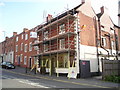
Refurbished frontages, Saltisford, Warwick
No 20 West Rock is on the left. Saltisford becomes the Birmingham Road, A4177, formerly the A41.
Image: © Robin Stott
Taken: 22 Feb 2020
0.03 miles
7
Victoria Street seen from Edward Street, Warwick
Image: © Robin Stott
Taken: 13 Jul 2009
0.03 miles
8
![Warwick buildings [128]](https://s0.geograph.org.uk/geophotos/06/62/81/6628172_a60293ed_120x120.jpg)
Warwick buildings [128]
The Black Horse, number 62 Saltisford, is a long established coaching inn to which carriers continued to call until 1916.
A market town and county town of Warwickshire, Warwick lies on the River Avon, 11 miles (18 kilometres) south of Coventry. There is evidence of unbroken habitation from the 6th century AD with signs of Neolithic and Roman activity before that date. It was a Saxon burh in the 9th century and Warwick Castle was built during the Norman Conquest. Much of the town was destroyed in The Great Fire of Warwick in 1694. Warwick Racecourse is located just west of the town centre. The Grand Union Canal passes through the town and the restored Saltisford Canal Arm is close to the town centre.
Image: © Michael Dibb
Taken: 4 Aug 2020
0.03 miles
9
![Warwick features [16]](https://s2.geograph.org.uk/geophotos/06/62/81/6628174_c0e74961_120x120.jpg)
Warwick features [16]
A notice on the wall of the Black Horse Inn Image giving details of a local highwayman.
A market town and county town of Warwickshire, Warwick lies on the River Avon, 11 miles (18 kilometres) south of Coventry. There is evidence of unbroken habitation from the 6th century AD with signs of Neolithic and Roman activity before that date. It was a Saxon burh in the 9th century and Warwick Castle was built during the Norman Conquest. Much of the town was destroyed in The Great Fire of Warwick in 1694. Warwick Racecourse is located just west of the town centre. The Grand Union Canal passes through the town and the restored Saltisford Canal Arm is close to the town centre.
Image: © Michael Dibb
Taken: 4 Aug 2020
0.03 miles
10
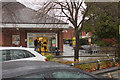
Sainsbury's Supermarket Entrance, Warwick
Image: © Mark Anderson
Taken: 14 Nov 2015
0.04 miles