IMAGES TAKEN NEAR TO
Castle Lane, WARWICK, CV34 4DA
Introduction
This page details the photographs taken nearby to Castle Lane, CV34 4DA by members of the Geograph project.
The Geograph project started in 2005 with the aim of publishing, organising and preserving representative images for every square kilometre of Great Britain, Ireland and the Isle of Man.

There are currently over 7.5m images from over14,400 individuals and you can help contribute to the project by visiting https://www.geograph.org.uk
Image Map
Images are licensed for reuse under creativecommons.org/licenses/by-sa/2.0
Notes
- Clicking on the map will re-center to the selected point.
- The higher the marker number, the further away the image location is from the centre of the postcode.
Image Listing (1138 Images Found)
Images are licensed for reuse under creativecommons.org/licenses/by-sa/2.0
Image
Details
Distance
1
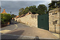
Bend in Castle Lane, Warwick
Viewed from the corner of Castle Close. The perimeter wall of Warwick Castle grounds is on the right.
Image: © Jaggery
Taken: 3 Oct 2015
0.01 miles
2
Sharp corner of Castle Lane, Warwick, at its southwest end
The view is from the mouth of Castle Close. The junction with West Street is just visible on the left. The wall of the Castle grounds is just visible on the right.
Image: © Robin Stott
Taken: 20 Sep 2013
0.02 miles
3
Castle Lane, Warwick
From the corner of West Street. Double yellow lines on both sides of the lane indicate no parking at any time.
Image: © Jaggery
Taken: 3 Oct 2015
0.02 miles
4

Castle Lane, Warwick
King's Lodge http://www.geograph.org.uk/photo/4686822 is on the right, a perimeter wall at the western edge of Warwick Castle grounds on the left.
In between, double yellow lines on both sides of the narrow lane indicate no parking at any time.
Image: © Jaggery
Taken: 3 Oct 2015
0.02 miles
5
Northeast on Castle Lane, Warwick
The wall of local stone is the boundary of Warwick Castle's grounds, extended in the eighteenth century.
Image: © Robin Stott
Taken: 20 Sep 2013
0.02 miles
6
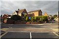
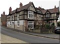
Southwest end of Castle Lane, Warwick
The view is from across West Street. The house edging in on the right is No.21.
Image: © Robin Stott
Taken: 20 Sep 2013
0.02 miles
7
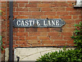
Enamel street nameplate, Castle Lane, Warwick
Image: © Robin Stott
Taken: 20 Sep 2013
0.02 miles
8

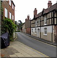
15-19 West Street, Warwick
A busy traffic node in Warwick: West Street continues uphill as High Street; it's a tight space between St James's Chapel above Westgate and the raised footway on the corner of Leycester Place. See also Image and Image Bowling Green Street, a switchback way round the town centre, goes off to the left. Castle Lane, handy for on-street parking, comes in from the right.
Image: © Robin Stott
Taken: 20 Sep 2013
0.02 miles
9
Corner of Castle Lane and West Street, Warwick
The narrow street is Castle Lane.
Image: © Jaggery
Taken: 3 Oct 2015
0.02 miles
10
From Castle Lane to Castle Close, Warwick
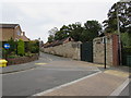
Castle Lane is on the left, Castle Close on the right.
Not in public use, the gate on the left is in the perimeter wall of Warwick Castle grounds.
Image: © Jaggery
Taken: 3 Oct 2015
0.02 miles