IMAGES TAKEN NEAR TO
Church Street, WARWICK, CV34 4AB
Introduction
This page details the photographs taken nearby to Church Street, CV34 4AB by members of the Geograph project.
The Geograph project started in 2005 with the aim of publishing, organising and preserving representative images for every square kilometre of Great Britain, Ireland and the Isle of Man.

There are currently over 7.5m images from over14,400 individuals and you can help contribute to the project by visiting https://www.geograph.org.uk
Image Map
Images are licensed for reuse under creativecommons.org/licenses/by-sa/2.0
Notes
- Clicking on the map will re-center to the selected point.
- The higher the marker number, the further away the image location is from the centre of the postcode.
Image Listing (1551 Images Found)
Images are licensed for reuse under creativecommons.org/licenses/by-sa/2.0
Image
Details
Distance
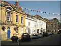
2
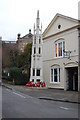
The Athenaeum, Church Street, Warwick
The Warwick and County Club. Dates from the eighteenth century https://historicengland.org.uk/listing/the-list/list-entry/1364798 being built after the fire of 1694.
Image: © Jonathan Thacker
Taken: 29 Sep 2019
0.01 miles
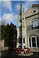
4
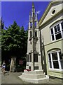
War Memorial, Church Street, Warwick
Dates from 1921 and designed by C.E. Bateman.
Image: © Jonathan Thacker
Taken: 29 Sep 2019
0.01 miles
5
![Warwick buildings [24]](https://s1.geograph.org.uk/geophotos/06/58/85/6588517_61b927a4_120x120.jpg)
Warwick buildings [24]
The Atehaeum, number 10 Church Street is 18th century with a monumental facade of ashlar and Roman cement. The building seemingly was restored in the 19th century. Occupied in 1846 by a club "established to afford 'facilities for moral and intellectual improvement, by the aid of a library, reading, and news room'". Until recently the building was occupied by The Warwick & County Club. Now used as offices with apartments above. Listed, grade II*, with details at: https://historicengland.org.uk/listing/the-list/list-entry/1364798
A market town and county town of Warwickshire, Warwick lies on the River Avon, 11 miles (18 kilometres) south of Coventry. There is evidence of unbroken habitation from the 6th century AD with signs of Neolithic and Roman activity before that date. It was a Saxon burh in the 9th century and Warwick Castle was built during the Norman Conquest. Much of the town was destroyed in The Great Fire of Warwick in 1694. Warwick Racecourse is located just west of the town centre. The Grand Union Canal passes through the town and the restored Saltisford Canal Arm is close to the town centre.
Image: © Michael Dibb
Taken: 5 Aug 2020
0.01 miles
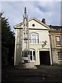
7
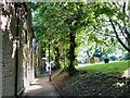
The Tink-a-Tank, Warwick
The Tink-a-Tank is a footpath between The Butts and Church Street by the War Memorial. The name imitates the sound of hard heels on the path. To the north (right) is St Mary's churchyard.
Image: © Robin Stott
Taken: 25 Jun 2022
0.01 miles
8
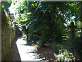
The Tink-a-tank, Warwick: 1
It's a footpath that runs between Church Street and the Butts, to the south of the churchyard and College Gardens. The name echoes the sound of hard shoes on the path, amplified by the walls. The view is towards Church Street.
Image: © Robin Stott
Taken: 11 Jul 2010
0.01 miles
9
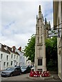
War Memorial, Warwick
On Church Street, next to the Old Library on the right
Image: © Paul Harrop
Taken: 16 May 2015
0.01 miles
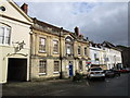
10
Looking down Church Street to the Court House
Image: © Robin Stott
Taken: 22 Jul 2012
0.01 miles