
IMAGES TAKEN NEAR TO
Blue Wood Avenue, COVENTRY, CV3 3DJ
Introduction
This page details the photographs taken nearby to Blue Wood Avenue, CV3 3DJ by members of the Geograph project.
The Geograph project started in 2005 with the aim of publishing, organising and preserving representative images for every square kilometre of Great Britain, Ireland and the Isle of Man.

There are currently over 7.5m images from over14,400 individuals and you can help contribute to the project by visiting https://www.geograph.org.uk
Image Map
Images are licensed for reuse under creativecommons.org/licenses/by-sa/2.0
Notes
- Clicking on the map will re-center to the selected point.
- The higher the marker number, the further away the image location is from the centre of the postcode.
Image Listing (60 Images Found)
Images are licensed for reuse under creativecommons.org/licenses/by-sa/2.0
Image
Details
Distance
1
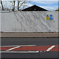
A glimpse of the former Chace Guildhouse from Chace Avenue, Willenhall, Coventry
Extensive hostel accommodation in Willenhall was first laid out in 1941 for war workers and refugees. The original site to the east of Chace Avenue (behind the camera) was redeveloped for housing in the late 1980s, I think. The hostel accommodation was replaced by the Chace Centre, latterly described as a supported living centre for homeless people. The Chase Guildhouse provided a range of facilities for residents. The replacement for the Chace Centre is the Gateway Centre of Excellence in Hillfields, Coventry, opened in 2015. The Chace site is to be redeveloped for over 75 mixed tenure homes.
The sky was clearing after an icy, late April shower.
Image: © Robin Stott
Taken: 30 Apr 2016
0.01 miles
2
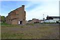
Demolition of the Chace Centre, Chace Avenue, Willenhall, Coventry
Extensive hostel accommodation in Willenhall was first laid out in 1941 for war workers and refugees. The original site to the east of Chace Avenue was redeveloped for housing in the late 1980s, I think. The hostel accommodation was replaced by four blocks in the Chace Centre, latterly described as a supported living centre for homeless people. On the left is Calcott House awaiting demolition. The other blocks were Allard House, Arna House and Deasy House. They first appear on an OS map of 1992. On the right is the Chase Guildhouse which I believe provided a range of facilities for residents. The replacement for the Chace Centre is the Gateway Centre of Excellence in Hillfields, Coventry, opened in 2015. The Chace site is to be redeveloped for over 75 mixed tenure homes.
In the distance, centre, is Willenhall police station: Image The sky was clearing after an icy, late April shower.
Image: © Robin Stott
Taken: 30 Apr 2016
0.02 miles
3
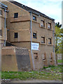
North end of derelict Calcott House, former Chace Centre, Willenhall, Coventry
Calcott House was one of four similar blocks in the Chace Centre, latterly described as a supported living centre for homeless people. The Salvation Army logo appears on the sign. The other blocks were Allard House, Arna House and Deasy House. They first appear on an OS map of 1992. Extensive hostel accommodation in Willenhall was first laid out in 1941 for war workers and refugees. The replacement for the Chace Centre is the Gateway Centre of Excellence in Hillfields, Coventry, opened in 2015. The Chace site is to be redeveloped for over 75 mixed tenure homes.
The sky is clearing after an icy, late April shower.
Image: © Robin Stott
Taken: 30 Apr 2016
0.03 miles
4
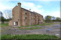
Derelict Calcott House, former Chace Centre, Willenhall, Coventry
Calcott House was one of four similar blocks in the Chace Centre, latterly described as a supported living centre for homeless people. The other blocks, recently demolished, were Allard House, Arna House and Deasy House. They first appear on an OS map of 1992. Extensive hostel accommodation in Willenhall was first laid out in 1941 for war workers and refugees. The replacement for the Chace Centre is the Gateway Centre of Excellence in Hillfields, Coventry, opened in 2015. The Chace site is to be redeveloped for over 75 mixed tenure homes.
The sky is clearing after an icy, late April shower.
Image: © Robin Stott
Taken: 30 Apr 2016
0.04 miles
5
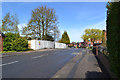
North on Chace Avenue, Willenhall, Coventry
Extensive hostel accommodation in Willenhall was first laid out in 1941 for war workers and refugees. The original site to the east of Chace Avenue, right, was redeveloped for housing in the late 1980s, I think. The hostel accommodation was replaced by the Chace Centre, latterly described as a supported living centre for homeless people. It is now in course of demolition by City Demolition, behind the white hoarding.
Image: © Robin Stott
Taken: 30 Apr 2016
0.04 miles
6
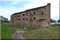
Derelict Calcott House, Chace Avenue, Willenhall, Coventry
Calcott House was one of four similar blocks in the Chace Centre, latterly described as a supported living centre for homeless people. The other blocks were Allard House, Arna House and Deasy House. They first appear on an OS map of 1992. Extensive hostel accommodation in Willenhall was first laid out in 1941 for war workers and refugees. The replacement for the Chace Centre is the Gateway Centre of Excellence in Hillfields, Coventry, opened in 2015. The Chace site is to be redeveloped for over 75 mixed tenure homes.
The sky is clearing after an icy, late April shower.
Image: © Robin Stott
Taken: 30 Apr 2016
0.04 miles
7
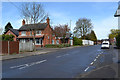
Surgery and pharmacy, Chace Lane, Willenhall, southeast Coventry
The white fence encloses the site of the Chace Centre, undergoing demolition. On the right is Dell Close.
Image: © Robin Stott
Taken: 30 Apr 2016
0.04 miles
8
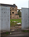
First glimpse of Calcott House, Chace Centre, Willenhall, southeast Coventry
The building was a shock – and the gap in the fence an invitation…
Image: © Robin Stott
Taken: 30 Apr 2016
0.04 miles
9
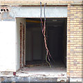
Detail of the south end of derelict Calcott House, Willenhall, Coventry
Image: © Robin Stott
Taken: 30 Apr 2016
0.04 miles
10
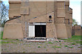
South end of derelict Calcott House, Chace Centre, Willenhall, Coventry
The thoughts bubble up at the detailing of this building.
Image: © Robin Stott
Taken: 30 Apr 2016
0.04 miles