IMAGES TAKEN NEAR TO
Simpkins Close, LEAMINGTON SPA, CV33 9GE
Introduction
This page details the photographs taken nearby to Simpkins Close, CV33 9GE by members of the Geograph project.
The Geograph project started in 2005 with the aim of publishing, organising and preserving representative images for every square kilometre of Great Britain, Ireland and the Isle of Man.

There are currently over 7.5m images from over14,400 individuals and you can help contribute to the project by visiting https://www.geograph.org.uk
Image Map (Loading...)


Getting Data...Please wait
Leaflet Map data © OpenStreetMap
Images are licensed for reuse under creativecommons.org/licenses/by-sa/2.0
Notes
- Clicking on the map will re-center to the selected point.
- The higher the marker number, the further away the image location is from the centre of the postcode.
Image Listing (18 Images Found)
Images are licensed for reuse under creativecommons.org/licenses/by-sa/2.0
Image
Details
Distance
1
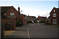
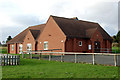
Alderman Way, Weston under Wetherley
Part of the densely-packed redevelopment of Weston Hospital.
Image: © Robin Stott
Taken: 1 Nov 2009
0.04 miles
2
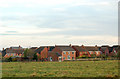
Houses crammed together on an 'executive' estate, Weston under Wetherley
Image: © Andy F
Taken: 27 Oct 2009
0.05 miles
3
Sabin Drive, Weston under Wetherley
The avenue of limes led to the former Weston Hospital, closed and redeveloped for housing in the 1990s.
Image: © Robin Stott
Taken: 1 Nov 2009
0.06 miles
4
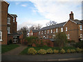
Former hospital buildings, Weston under Wetherley
These buildings were retained and converted following the closure and redevelopment of Weston Hospital in the 1990s. As a Reformatory School for Insane Persons, it was taken over by Warwickshire County Council in 1929 to form the nucleus of a 'colony' – a more-or-less self-supporting community of people with mental illness or learning disability – a satellite of the central mental hospital at Hatton near Warwick Image Ten years on OS Explorer is still showing the hospital surrounded by a jumble of ancillary buildings including a water tower that has been demolished.
Image: © Robin Stott
Taken: 1 Nov 2009
0.07 miles
5
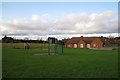
Play area and village hall, Weston under Wetherley
Provided through a planning agreement with the developer of the Weston Hospital site (behind the camera). The view is towards the rear of county council houses on the B4453.
Image: © Robin Stott
Taken: 1 Nov 2009
0.08 miles
6
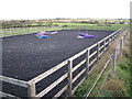
A rather small man?ge, Weston under Wetherley
Aerial photos of this redevelopment of Weston Hospital show at least three properties with an associated manège (a riding school or an enclosure for training horses – mid-Warwickshire is full of them). This one, and some horses, are behind the Old Courtyard, the retained and converted core buildings of the original Reformatory School for Insane Persons that was taken over by the county council in 1929 to form the nucleus of a 'colony'.
The view is across the Leam valley towards Hunningham Hill.
Image: © Robin Stott
Taken: 1 Nov 2009
0.12 miles
7
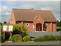
Weston under Wetherley Village Hall
The village hall on Sabin Drive was opened in November 1999.
Image: © Stephen McKay
Taken: 11 Sep 2007
0.12 miles
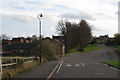
10
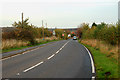
Looking east on the B4453 in Weston under Wetherley
Image: © Andy F
Taken: 27 Oct 2009
0.15 miles