IMAGES TAKEN NEAR TO
Sabin Drive, LEAMINGTON SPA, CV33 9GA
Introduction
This page details the photographs taken nearby to Sabin Drive, CV33 9GA by members of the Geograph project.
The Geograph project started in 2005 with the aim of publishing, organising and preserving representative images for every square kilometre of Great Britain, Ireland and the Isle of Man.

There are currently over 7.5m images from over14,400 individuals and you can help contribute to the project by visiting https://www.geograph.org.uk
Image Map (Loading...)


Getting Data...Please wait
Leaflet Map data © OpenStreetMap
Images are licensed for reuse under creativecommons.org/licenses/by-sa/2.0
Notes
- Clicking on the map will re-center to the selected point.
- The higher the marker number, the further away the image location is from the centre of the postcode.
Image Listing (28 Images Found)
Images are licensed for reuse under creativecommons.org/licenses/by-sa/2.0
Image
Details
Distance
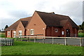
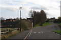
2
Weston under Wetherley Village Hall
The village hall on Sabin Drive was opened in November 1999.
Image: © Stephen McKay
Taken: 11 Sep 2007
0.02 miles
3
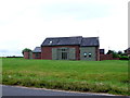
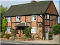
House in Weston
This appeared to be a recently converted barn that stands on its own close to the centre of the village. The space around it is very open.
Image: © Nigel Mykura
Taken: 7 Aug 2012
0.05 miles
4
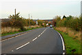
Looking east on the B4453 in Weston under Wetherley
Image: © Andy F
Taken: 27 Oct 2009
0.06 miles
6
Bramley Cottage, Weston under Wetherley
Attractive cottage on Rugby Road close to the junction with Sabin Drive.
Image: © Stephen McKay
Taken: 11 Sep 2007
0.07 miles
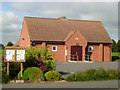
7
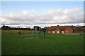
Play area and village hall, Weston under Wetherley
Provided through a planning agreement with the developer of the Weston Hospital site (behind the camera). The view is towards the rear of county council houses on the B4453.
Image: © Robin Stott
Taken: 1 Nov 2009
0.07 miles
8
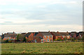
Houses crammed together on an 'executive' estate, Weston under Wetherley
Image: © Andy F
Taken: 27 Oct 2009
0.09 miles
9
Sabin Drive, Weston under Wetherley
The avenue of limes led to the former Weston Hospital, closed and redeveloped for housing in the 1990s.
Image: © Robin Stott
Taken: 1 Nov 2009
0.11 miles
10
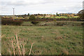
Fields east of Sabin Drive, Weston under Wetherley
Looking in the direction of Wappenbury Image The road to Hunningham crosses the picture between solid hedges.
Image: © Robin Stott
Taken: 1 Nov 2009
0.14 miles