IMAGES TAKEN NEAR TO
Weston Under Wetherley, LEAMINGTON SPA, CV33 9BT
Introduction
This page details the photographs taken nearby to CV33 9BT by members of the Geograph project.
The Geograph project started in 2005 with the aim of publishing, organising and preserving representative images for every square kilometre of Great Britain, Ireland and the Isle of Man.

There are currently over 7.5m images from over14,400 individuals and you can help contribute to the project by visiting https://www.geograph.org.uk
Image Map
Images are licensed for reuse under creativecommons.org/licenses/by-sa/2.0
Notes
- Clicking on the map will re-center to the selected point.
- The higher the marker number, the further away the image location is from the centre of the postcode.
Image Listing (8 Images Found)
Images are licensed for reuse under creativecommons.org/licenses/by-sa/2.0
Image
Details
Distance
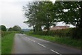
2
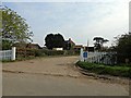
Entrance to Fields Farms
Although the map calls this farm Weston Fields Farm the sign says Fields Farm , Weston
Image: © Nigel Mykura
Taken: 4 Mar 2012
0.08 miles
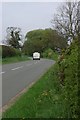
3
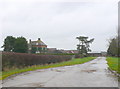
Weston Fields Farm
This farm unlike many in the area which have been converted to residential use is still a large working farm.
Image: © Nigel Mykura
Taken: 4 Mar 2012
0.09 miles
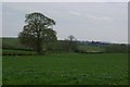
5
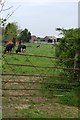
Across the fields to Weston Fields Farm
Image: © Keith Williams
Taken: 24 Apr 2009
0.10 miles