IMAGES TAKEN NEAR TO
Dunvegan Close, COVENTRY, CV3 2PA
Introduction
This page details the photographs taken nearby to Dunvegan Close, CV3 2PA by members of the Geograph project.
The Geograph project started in 2005 with the aim of publishing, organising and preserving representative images for every square kilometre of Great Britain, Ireland and the Isle of Man.

There are currently over 7.5m images from over14,400 individuals and you can help contribute to the project by visiting https://www.geograph.org.uk
Image Map
Images are licensed for reuse under creativecommons.org/licenses/by-sa/2.0
Notes
- Clicking on the map will re-center to the selected point.
- The higher the marker number, the further away the image location is from the centre of the postcode.
Image Listing (6 Images Found)
Images are licensed for reuse under creativecommons.org/licenses/by-sa/2.0
Image
Details
Distance
1
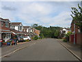
Gainford Rise, Binley
A quiet modern development in the SW corner of the square - with the busy Coventry eastern bypass beyond the hedge.
Image: © David Stowell
Taken: 5 Aug 2005
0.15 miles
2
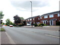
Houses on Clifford Bridge Road
These modern semi-detached houses are on the B4082, which runs along the eastern side of the River Sowe and crosses the river at Sowe Bridge.
Image: © Nigel Mykura
Taken: 15 May 2023
0.15 miles
5
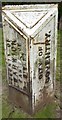
Old Boundary Marker by the B4428, Brinklow Road, Coventry
Parish Boundary Marker in parish of Coventry (Coventry District), B4428, Brinklow Road.
To be surveyed
Milestone Society National ID: WA_COVBI2pb.
Image: © Milestone Society
Taken: Unknown
0.21 miles
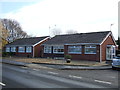
6
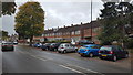
The B4082 in Binley
Housing on the B4082 in Binley, Coventry.
Image: © Peter Mackenzie
Taken: 2 Oct 2018
0.23 miles