IMAGES TAKEN NEAR TO
Granborough Close, COVENTRY, CV3 2FH
Introduction
This page details the photographs taken nearby to Granborough Close, CV3 2FH by members of the Geograph project.
The Geograph project started in 2005 with the aim of publishing, organising and preserving representative images for every square kilometre of Great Britain, Ireland and the Isle of Man.

There are currently over 7.5m images from over14,400 individuals and you can help contribute to the project by visiting https://www.geograph.org.uk
Image Map
Images are licensed for reuse under creativecommons.org/licenses/by-sa/2.0
Notes
- Clicking on the map will re-center to the selected point.
- The higher the marker number, the further away the image location is from the centre of the postcode.
Image Listing (9 Images Found)
Images are licensed for reuse under creativecommons.org/licenses/by-sa/2.0
Image
Details
Distance
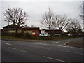
2
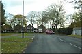
Willenhall Lane, Binley
When the council built this housing in the 1960's, they also dualled this section of Willenhall Lane, as it was at that time the main route around the eastern edge of the city. It was proposed that this might become part of an outer ring road, a plan which the city had been progressing slowly since the 1930's. However when the A46 Eastern Bypass was eventually opened in 1989, it took a route further to the east. The section of road in Willenhall Lane has never been used as anything but a service road. The traffic on the main part of Willenhall Lane can just be seen on the left.
Image: © John Brightley
Taken: 3 Jun 2010
0.20 miles
3

'Ltd Superslore'
Remains of signage at the former Stockroom furniture store, Willenhall Lane, Binley.
Image: © John Brightley
Taken: 3 Jun 2010
0.20 miles
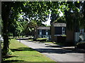
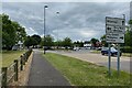
4
Roundabout at the junction of Willenhall Lane and Brandon Road, Binley
Image: © John Brightley
Taken: 3 Jun 2010
0.21 miles
5
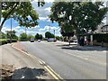
Northwest on Brandon Road, Binley, Covemtry
Image: © Robin Stott
Taken: 20 Jun 2022
0.23 miles
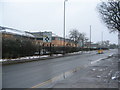
6
Bus stops on Brandon Road, Binley, Coventry
Image: © Robin Stott
Taken: 20 Jun 2022
0.23 miles
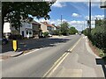
7
Brandon Road, Binley
Brandon Road near the junction with Willenhall Lane. The building on the left, in Binley Business Park, stands on the site of the former Binley Park Comprehensive School which stood there from 1959-1990.
Image: © E Gammie
Taken: 14 Jan 2013
0.24 miles
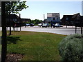
8
New Abbeyfield development, Brandon Road
When you enlarge the current map for this building it looks like an aeroplane, strange.
Image: © Anthony Vosper
Taken: 17 Feb 2012
0.24 miles
9
South on Harry Weston Road, Binley, Coventry
Harry Weston Road leads out of Binley Business Park.
Image: © Robin Stott
Taken: 23 May 2022
0.24 miles