IMAGES TAKEN NEAR TO
Clifford Bridge Road, COVENTRY, CV3 2AE
Introduction
This page details the photographs taken nearby to Clifford Bridge Road, CV3 2AE by members of the Geograph project.
The Geograph project started in 2005 with the aim of publishing, organising and preserving representative images for every square kilometre of Great Britain, Ireland and the Isle of Man.

There are currently over 7.5m images from over14,400 individuals and you can help contribute to the project by visiting https://www.geograph.org.uk
Image Map
Images are licensed for reuse under creativecommons.org/licenses/by-sa/2.0
Notes
- Clicking on the map will re-center to the selected point.
- The higher the marker number, the further away the image location is from the centre of the postcode.
Image Listing (35 Images Found)
Images are licensed for reuse under creativecommons.org/licenses/by-sa/2.0
Image
Details
Distance
1
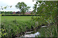
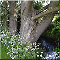
Hungerley Hall Farm across the River Sowe, Walsgrave, Coventry
The farm is sandwiched between the river and the A46 Coventry Eastern Bypass. Rafts of hawthorn petals have collected on the water.
Image: © Robin Stott
Taken: 2 Jun 2016
0.00 miles
2
A glimpse of Hungerley Hall Farm across the Sowe, Walsgrave, east Coventry
Image: © Robin Stott
Taken: 2 Jun 2016
0.03 miles
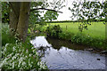
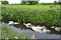
3
Watering place for livestock, River Sowe, Walsgrave, Coventry
Probably on Hungerley Hall Farm.
Image: © Robin Stott
Taken: 2 Jun 2016
0.09 miles
4
River Sowe beneath big poplars, Walsgrave, Coventry
The view is from the Sowe Valley footpath across to Hungerley Hall Farm pasture.
Image: © Robin Stott
Taken: 2 Jun 2016
0.10 miles
5
Poplars and Cow Parsley by the River Sowe, Walsgrave, east Coventry
Image: © Robin Stott
Taken: 2 Jun 2016
0.11 miles
6
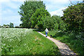
An afternoon walk with the dog by the Sowe, Walsgrave, east Coventry
The River Sowe flows among trees; looking upstream.
Image: © Robin Stott
Taken: 2 Jun 2016
0.11 miles
7
Mats of petals on the River Sowe, Walsgrave, Coventry
The white petals of hawthorn and cow parsley have fallen to the river, collecting as mats where stands of waterweed slow the flow. The view is from the Sowe Valley footpath.
Image: © Robin Stott
Taken: 2 Jun 2016
0.12 miles
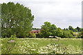
8
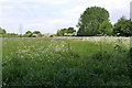
Early summer in the Sowe valley, Walsgrave, Coventry
This is the floodmeadow east of the Tesco store in Clifford Bridge Road. Cow Parsley and Hogweed are flowering among coarse meadow grasses. The river runs among the trees – hawthorn (in flower), ash, and huge hybrid poplars.
The following January it looked like this: Image
Image: © Robin Stott
Taken: 2 Jun 2016
0.13 miles
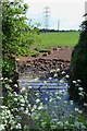
9
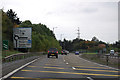
A46 approaching roundabout near Binley
The B4082 is to the right. The hospital is now the University Hospital, Coventry, formerly known as Walsgrave Hospital.
Image: © J.Hannan-Briggs
Taken: 13 Oct 2016
0.13 miles
10
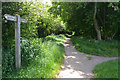
The Sowe Valley Footpath is joined by the path past Tesco, Walsgrave, east Coventry
Image: © Robin Stott
Taken: 2 Jun 2016
0.15 miles