IMAGES TAKEN NEAR TO
Kenilworth Road, LEAMINGTON SPA, CV32 7TN
Introduction
This page details the photographs taken nearby to Kenilworth Road, CV32 7TN by members of the Geograph project.
The Geograph project started in 2005 with the aim of publishing, organising and preserving representative images for every square kilometre of Great Britain, Ireland and the Isle of Man.

There are currently over 7.5m images from over14,400 individuals and you can help contribute to the project by visiting https://www.geograph.org.uk
Image Map
Images are licensed for reuse under creativecommons.org/licenses/by-sa/2.0
Notes
- Clicking on the map will re-center to the selected point.
- The higher the marker number, the further away the image location is from the centre of the postcode.
Image Listing (42 Images Found)
Images are licensed for reuse under creativecommons.org/licenses/by-sa/2.0
Image
Details
Distance
1
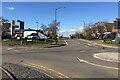
Northwest on Kenilworth Road from the crossroads, Cubbington
A reverse view is Image
Image: © Robin Stott
Taken: 26 Feb 2021
0.01 miles
3
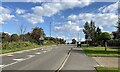
Northwest on Kenilworth Road, Cubbington, with two wagons
It's possible that the wagons are carrying spoil from HS2 excavations north of Cubbington village. They'll be heading for the A445 Leicester Lane north.
Image: © Robin Stott
Taken: 16 Sep 2021
0.05 miles
4
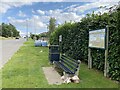
Parish Council presence, Kenilworth Road
Where does Cubbington start? A question to be pursued.
Image: © Robin Stott
Taken: 16 Sep 2021
0.07 miles
5
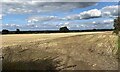
Fields on the edge of Cubbington
The Coventry skyline can just be made out in this image.
Image: © AJD
Taken: Unknown
0.07 miles
6
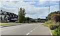
Kenilworth Road arrives in Cubbington
So many signs! They signal arrival at a place where there are goods and services to be had, however unlikely. The covered lorry, centre, is likely to be carrying grain to a store: it's harvest time.
Image: © Robin Stott
Taken: 16 Sep 2021
0.07 miles
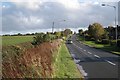
7
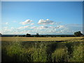
Stubble field by Kenilworth Road, Cubbington
In the distance half left is the ever-changing skyline of Coventry. The landscape beyond this field will be crossed by HS2.
Image: © Robin Stott
Taken: 16 Sep 2021
0.08 miles
8
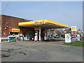
Service station on Rugby Road (B4453), Cubbington
Image: © JThomas
Taken: 28 Mar 2014
0.09 miles
9
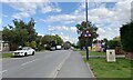
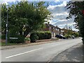
Kenilworth Road, New Cubbington
Looking from near Balmoral Way towards the Rugby Road, which runs on a ridge here. Properties on the north side of the road can be seen, left.
Image: © Robin Stott
Taken: 24 Oct 2009
0.09 miles
10
Southwest on Beaufort Avenue, Lillington
Another of the roads on this old estate named after Scottish places and people.
Image: © Robin Stott
Taken: 16 Sep 2021
0.10 miles