IMAGES TAKEN NEAR TO
Brookfield Road, LEAMINGTON SPA, CV32 7NE
Introduction
This page details the photographs taken nearby to Brookfield Road, CV32 7NE by members of the Geograph project.
The Geograph project started in 2005 with the aim of publishing, organising and preserving representative images for every square kilometre of Great Britain, Ireland and the Isle of Man.

There are currently over 7.5m images from over14,400 individuals and you can help contribute to the project by visiting https://www.geograph.org.uk
Image Map (Loading...)


Getting Data...Please wait
Leaflet Map data © OpenStreetMap
Images are licensed for reuse under creativecommons.org/licenses/by-sa/2.0
Notes
- Clicking on the map will re-center to the selected point.
- The higher the marker number, the further away the image location is from the centre of the postcode.
Image Listing (77 Images Found)
Images are licensed for reuse under creativecommons.org/licenses/by-sa/2.0
Image
Details
Distance
1
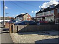
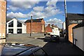
Shops, Queen Street, Cubbington
The Costcutter displays a Post Office sign, confirmed by the modern map. The cul-de-sac Hill Crest runs through the space between the Costcutter and the convenience store left of centre.
Image: © Robin Stott
Taken: 26 Feb 2021
0.08 miles
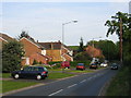
2
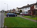
Cubbington
This is the Welsh Road at Cubbington on the outskirts of Leamington. Cubbington has some large modern areas which are part of Leamington. These modern houses are on the southern edge of the old village on Windmill Hill
Image: © Nigel Mykura
Taken: 19 Feb 2011
0.09 miles
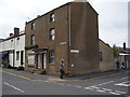
4
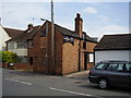
The Warwickshire Beer Company
A micro brewery in Queen St, Cubbington.
Image: © Anthony Vosper
Taken: 25 May 2011
0.09 miles
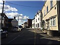
5
Junction of Queen Street and High Street, Cubbington
The Ledbrook Road turning, left, marks the change from Queen Street, foreground, to High Street beyond. On the corner, an alien has landed. The former chapel, centre, is believed to have been used as a store for a local removal company though it appears now to be two or more private dwellings. A plaque is inscribed 'Ledbrook Hall 1844'.
Image: © Robin Stott
Taken: 26 Feb 2021
0.10 miles
7
Still empty and shut
Taken from a different direction. This boarded up shop in Queen street has not changed from a photograph submitted nearly four years ago.
Image: © Anthony Vosper
Taken: 25 May 2011
0.11 miles
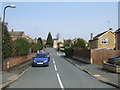
8
Cubbington
Looking towards the Welsh Road leading to Offchurch
Image: © David Stowell
Taken: 12 May 2005
0.11 miles
10
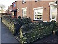
Mossy stone walls to front gardens, Queen Street, Cubbington
Guessing, a porous stone in a shady location, being continuously damp, has developed and supported a blanket of moss.
Image: © Robin Stott
Taken: 26 Feb 2021
0.11 miles