IMAGES TAKEN NEAR TO
Windmill Croft, LEAMINGTON SPA, CV32 7JU
Introduction
This page details the photographs taken nearby to Windmill Croft, CV32 7JU by members of the Geograph project.
The Geograph project started in 2005 with the aim of publishing, organising and preserving representative images for every square kilometre of Great Britain, Ireland and the Isle of Man.

There are currently over 7.5m images from over14,400 individuals and you can help contribute to the project by visiting https://www.geograph.org.uk
Image Map
Images are licensed for reuse under creativecommons.org/licenses/by-sa/2.0
Notes
- Clicking on the map will re-center to the selected point.
- The higher the marker number, the further away the image location is from the centre of the postcode.
Image Listing (52 Images Found)
Images are licensed for reuse under creativecommons.org/licenses/by-sa/2.0
Image
Details
Distance
1
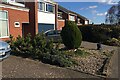
Conifers, front garden, Windmill Hill, Cubbington
On the far side a (clipped) Lawson Cypress variety, perhaps 'Erecta'. At the front a prostrate juniper and to its left a thriving Mountain Pine, Pinus mugo.
Image: © Robin Stott
Taken: 26 Feb 2021
0.02 miles
2
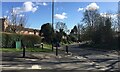
Junction of Windmill Hill and Stonehouse Close, Cubbington
Image: © Robin Stott
Taken: 26 Feb 2021
0.03 miles
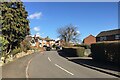
5
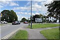
Kenilworth Road approaches Cubbington crossroads
This is the busy crossroads seen in Image The school run will be in full flow. The reverse view to Kenilworth Road is Image
Image: © Robin Stott
Taken: 16 Sep 2021
0.06 miles
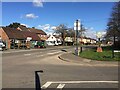
7
Cubbington crossroads and mini-roundabout
A farm tractor moves towards Windmill Hill from Kenilworth Road, left. Cubbington Road, foreground, continues as Rugby Road: a very busy junction.
Image: © Robin Stott
Taken: 26 Feb 2021
0.06 miles
8
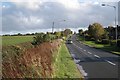
Kenilworth Road, New Cubbington
Looking from near Balmoral Way towards the Rugby Road, which runs on a ridge here. Properties on the north side of the road can be seen, left.
Image: © Robin Stott
Taken: 24 Oct 2009
0.07 miles
9
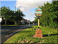
Cubbington
The smart sign at the cross roads approaching Cubbington
Image: © David Stowell
Taken: 22 May 2005
0.08 miles
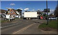
10
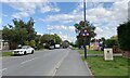
Kenilworth Road arrives in Cubbington
So many signs! They signal arrival at a place where there are goods and services to be had, however unlikely. The covered lorry, centre, is likely to be carrying grain to a store: it's harvest time.
Image: © Robin Stott
Taken: 16 Sep 2021
0.09 miles