IMAGES TAKEN NEAR TO
Norfolk Street, LEAMINGTON SPA, CV32 5YQ
Introduction
This page details the photographs taken nearby to Norfolk Street, CV32 5YQ by members of the Geograph project.
The Geograph project started in 2005 with the aim of publishing, organising and preserving representative images for every square kilometre of Great Britain, Ireland and the Isle of Man.

There are currently over 7.5m images from over14,400 individuals and you can help contribute to the project by visiting https://www.geograph.org.uk
Image Map (Loading...)


Getting Data...Please wait
Leaflet Map data © OpenStreetMap
Images are licensed for reuse under creativecommons.org/licenses/by-sa/2.0
Notes
- Clicking on the map will re-center to the selected point.
- The higher the marker number, the further away the image location is from the centre of the postcode.
Image Listing (241 Images Found)
Images are licensed for reuse under creativecommons.org/licenses/by-sa/2.0
Image
Details
Distance
1
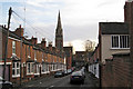
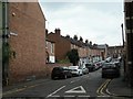
Suffolk Street, Leamington
Seen from near its junction with Villiers Street, behind the camera, looking towards St Paul's Church in Leicester Street. It was opened in 1874 though not completed and consecrated until 1878.
Image: © Robin Stott
Taken: 27 Oct 2009
0.03 miles
2
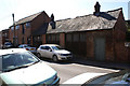
Old stable
An interesting old stable block that presumably once served one of the large houses nearby. At least part of the block is used by local electrical contractors but the building is looking a little tired and in need of TLC.
Image: © Colin Craig
Taken: 4 Apr 2009
0.03 miles
3
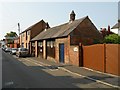
Leamington Spa-Hill Street
Workshop and garages.
Image: © Ian Rob
Taken: 5 Jul 2013
0.03 miles
4
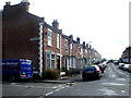
Villiers Street
One of many Victorian terraced streets on the northern side of the town centre. The road on the left is Waller Street though the sign high up on the wall can be read as Upper Hill Street. Hill Street is not visible off on the right.
Image: © Nigel Mykura
Taken: 28 Aug 2011
0.03 miles
5
Suffolk Street, off Leicester Street
The streets are laid out so that Leicester is south of Suffolk, and Norfolk is to the west.
Image: © Christine Johnstone
Taken: 18 May 2019
0.03 miles
6
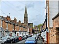
Suffolk Street
Looking down towards Leicester Street and St Paul's church.
Image: © Mike Parker
Taken: 27 Apr 2024
0.03 miles
7
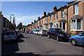
Villiers Street
This is a typical terrace built in late Victorian times in this part of Leamington Spa. Built to a smaller scale than houses on the nearby Lillington Road, which is lined with larger, often standalone, villas and houses.
Image: © Colin Craig
Taken: 4 Apr 2009
0.03 miles
8
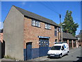
Workshop, Hill Street
Another one of the outbuildings at the rear of the large houses in Clarendon Street. Although probably originally built as a stables or coach house the premises are now the home of one of the local electrical contractors.
Image: © David Stowell
Taken: 28 Aug 2005
0.04 miles
9
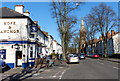
Hope & Anchor in Royal Leamington Spa
Public house on the corner of Hill Street and Leicester Street. In the distance is St Paul's Church.
Image: © Mat Fascione
Taken: 18 Apr 2015
0.04 miles
10
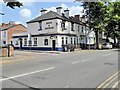
Hope and Anchor, Leicester Street
Public house at the corner of Hill Street and Leicester Street.
Image: © David Dixon
Taken: 21 Jul 2014
0.04 miles