IMAGES TAKEN NEAR TO
Sheepcote Close, LEAMINGTON SPA, CV32 5YD
Introduction
This page details the photographs taken nearby to Sheepcote Close, CV32 5YD by members of the Geograph project.
The Geograph project started in 2005 with the aim of publishing, organising and preserving representative images for every square kilometre of Great Britain, Ireland and the Isle of Man.

There are currently over 7.5m images from over14,400 individuals and you can help contribute to the project by visiting https://www.geograph.org.uk
Image Map
Images are licensed for reuse under creativecommons.org/licenses/by-sa/2.0
Notes
- Clicking on the map will re-center to the selected point.
- The higher the marker number, the further away the image location is from the centre of the postcode.
Image Listing (87 Images Found)
Images are licensed for reuse under creativecommons.org/licenses/by-sa/2.0
Image
Details
Distance
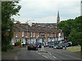
1
Villiers Street, Leamington
On the skyline are houses in Rosewood Crescent, seen from the rear. The sharp change of level results from the excavation of clay for the former Leamington Brickworks. Leamington brick was larger than today's standard brick. It was a pleasing pale orange and is seen in older buildings, mostly in Leamington.
Image: © Robin Stott
Taken: 27 Oct 2009
0.04 miles
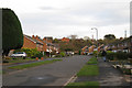
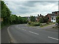
2
Leicester Street from the Campion Hills
There are not many hills of note in Leamington Spa, and this view is looking down the lower part of the steepest as the road descends from the Campion Hills. The traffic calming measures in the shadows were introduced to restrict the activities of boy-racers who used to speed down here.
Image: © David Stowell
Taken: 28 Aug 2005
0.06 miles
3
Leicester Court, off Leicester Street
An infill development on the eastern edge of Leamington Spa.
Image: © Christine Johnstone
Taken: 18 May 2019
0.06 miles
4
Chestnut Square, Royal Leamington Spa
This development occupies land that for many years was used for allotments. The house design attempts to match many of the older terraces in the town. Unfortunately however the architect failed to replicate the vertical proportions of the buildings with the result that these properties look like they have been partially squashed by a giant foot!
Image: © David Stowell
Taken: 28 Aug 2005
0.08 miles
5
Terraced houses on Leicester Street
On the eastern edge of Leamington Spa, below Campion Hill.
Image: © Christine Johnstone
Taken: 18 May 2019
0.08 miles
6
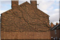
Waiting for summer
This Virginia creeper was rampant on the gable end of a house in Campion Terrace, Leamington Spa. It must look spectacular during summer.
Image: © Colin Craig
Taken: 29 Nov 2007
0.09 miles
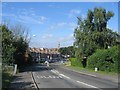
7
Leicester Street, descending into Leamington Spa
Here about 30 metres higher than the town centre [1km away].
Image: © Christine Johnstone
Taken: 18 May 2019
0.11 miles
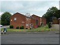
8
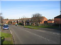
Gresham Avenue
This area was initially developed after WWII with prefabs similar in style to Image These were demolished and the area redeveloped in the 1970s and 80s to the form seen in this picture.
Image: © David Stowell
Taken: 17 Dec 2005
0.12 miles
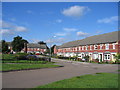
9
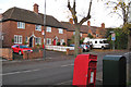
Leicester Street and postbox
After the First World War "servicemen returned to the town to find that, despite a government promise, there were not enough houses and many had to live in condemned slums which often accommodated more people than when first built." Housing Acts were passed to enable a housing programme to be set up … "Leamington's first council houses were built using space standards and layout which are quite generous by present-day criteria. They were used as examples in the Housing Commissioners' Design Manual and were repeated almost exactly in later manuals until after the Second World War."
These are some of those first council houses on the north side of Leicester Street, completed 1921-2. The postbox ID is CV32 69. Quotes from Lyndon Cave: Royal Leamington Spa, a history: 2009.
Image: © Robin Stott
Taken: 27 Oct 2009
0.12 miles
10
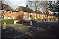
Leicester Street, Leamington Spa
Inter-war 'garden city' style local authority houses line the northern side of Leicester Street.
Image: © Stephen McKay
Taken: 23 Nov 2013
0.12 miles