IMAGES TAKEN NEAR TO
Warwick Street, LEAMINGTON SPA, CV32 5LW
Introduction
This page details the photographs taken nearby to Warwick Street, CV32 5LW by members of the Geograph project.
The Geograph project started in 2005 with the aim of publishing, organising and preserving representative images for every square kilometre of Great Britain, Ireland and the Isle of Man.

There are currently over 7.5m images from over14,400 individuals and you can help contribute to the project by visiting https://www.geograph.org.uk
Image Map (Loading...)


Getting Data...Please wait
Leaflet Map data © OpenStreetMap
Images are licensed for reuse under creativecommons.org/licenses/by-sa/2.0
Notes
- Clicking on the map will re-center to the selected point.
- The higher the marker number, the further away the image location is from the centre of the postcode.
Image Listing (493 Images Found)
Images are licensed for reuse under creativecommons.org/licenses/by-sa/2.0
Image
Details
Distance
1
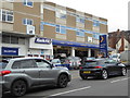
Kwik Fit - Royal Leamington Spa
Photographed from outside the Star and Garter at the Geograph 12th birthday event.
Image: © Chris Allen
Taken: 4 Mar 2017
0.00 miles
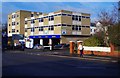
2
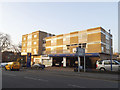
Building for sale, Warwick Street west, Leamington
The site lies between Upper Grove Street (nearest the camera) and Warwick Terrace. The west end of the site, also for sale in 2015, is seen in Image I should be sorry to see this branch of Kwik Fit go. The upper floors are presumed to be offices. This part of Leamington was a frenzy of speculative residential development in the 1820s and 1830s but this site seems to have remained vacant until the 1840s. The Board of Health map of 1852 shows a villa, Westrock House, fronting Upper Grove Street with a split-level garden down to Warwick Terrace. So it remained until the 1960s when the site is shown vacant on an OS map of 1966-70. A building, presumed to be the present block, appears on the 1972-74 map.
Image: © Robin Stott
Taken: 2 Oct 2018
0.00 miles
3
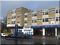
Kwik-Fit (1), Warwick Street, Royal Leamington Spa
Local branch of the specialist firm who fit tyres, exhausts, brakes & batteries, as well as carrying out other work on motor vehicles. This branch is a MOT Test Centre. It is located on the corner of Warwick Street and Upper Grove Street.
Image
Image: © P L Chadwick
Taken: 3 Feb 2015
0.01 miles
4
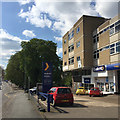
Tyre-fitting franchise, Warwick Street, Royal Leamington Spa
Between Upper Grove Street and Warwick Terrace. The trees are in the Dell.
Image: © Robin Stott
Taken: 18 Apr 2017
0.01 miles
5
Kwik-Fit, Warwick Place, Leamington Spa
Flats above a shop are common; flats above a motor workshop much less so.
Image: © Stephen Craven
Taken: 17 Nov 2018
0.01 miles
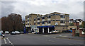
7
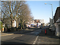
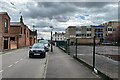
West end of Warwick Street by the Dell
The spacious approach to Leamington town centre from the west exhibits the characteristic mix of buildings of all periods, legacy of the gung-ho 'planning' regime of the old Leamington Corporation. On the right was a handy and very efficient sub-post office, now closed but the postbox remains: number CV32 22. On the left massive horse chestnuts shelter the southern end of the Dell, a small community open space in the former valley of the Binsbrook.
Image: © Robin Stott
Taken: 15 Jan 2012
0.01 miles
8
Kwik-Fit (2), Warwick Street, Royal Leamington Spa
See: Image
Image: © P L Chadwick
Taken: 3 Feb 2015
0.02 miles
9
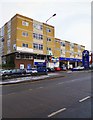
South on Upper Grove Street, Leamington
Here the twentieth century meets the Regency town centre. The properties on the left are the outbuildings (including one converted coach house) to the rear of the substantial Victorian houses in Clarendon Place. On the right, offices over a Kwik-fit tyre business face a surviving elegant frontage in Warwick Street. The little-known council car park on the right appears closed; perhaps development is in the offing.
Image: © Robin Stott
Taken: 11 Apr 2024
0.02 miles
10
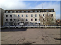
Private car park, Upper Grove Street, and rear of flats in Warwick Terrace, Leamington
Late 19th century maps show a large block, Somerset Mews, where this car park is. The 1923 OS map shows a Film Printing Works. A local woman remembers her mother saying that before she married in 1935 she was employed at a developing and printing works here. The signs at the back of the car park say 'Market Location', presumed to be a commercial property agent.
On the left is a glimpse of the back of a building that houses KwikFit with offices above. A report of 1944 mentions an office block on the site. In the late 19th century it was the site of a residential property, Westrock House. Its garden and a neighbouring one, shown in 1887, are the site of the flats that front Warwick Terrace. In form they approximate to the early 19th-century terrace at the north end of the street. See also http://geograph.org.uk/p/3944224
Image: © Robin Stott
Taken: 17 Feb 2013
0.02 miles