IMAGES TAKEN NEAR TO
The Boxhill, COVENTRY, CV3 1ES
Introduction
This page details the photographs taken nearby to The Boxhill, CV3 1ES by members of the Geograph project.
The Geograph project started in 2005 with the aim of publishing, organising and preserving representative images for every square kilometre of Great Britain, Ireland and the Isle of Man.

There are currently over 7.5m images from over14,400 individuals and you can help contribute to the project by visiting https://www.geograph.org.uk
Image Map
Images are licensed for reuse under creativecommons.org/licenses/by-sa/2.0
Notes
- Clicking on the map will re-center to the selected point.
- The higher the marker number, the further away the image location is from the centre of the postcode.
Image Listing (4 Images Found)
Images are licensed for reuse under creativecommons.org/licenses/by-sa/2.0
Image
Details
Distance
1
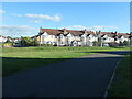
Houses on the east side of Aldermoor Lane, Coventry
Built in blocks of five, after 1945.
Image: © Christine Johnstone
Taken: 24 Sep 2021
0.21 miles
2
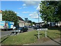
Round House Road, Stoke Aldermoor, Coventry
At the junction with a road called The Moorfield.
Image: © Christine Johnstone
Taken: 24 Sep 2021
0.21 miles
3
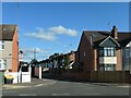
Molesworth Avenue, off Aldermoor Lane, Coventry
This cul-de-sac was planned by 1938, but the houses were not built until after 1945.
Image: © Christine Johnstone
Taken: 24 Sep 2021
0.22 miles
4
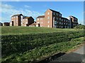
Housing on Signals Drive, Coventry
Built on the site of the Humber car factory.
Image: © Christine Johnstone
Taken: 24 Sep 2021
0.25 miles