IMAGES TAKEN NEAR TO
Pinley Fields, COVENTRY, CV3 1DD
Introduction
This page details the photographs taken nearby to Pinley Fields, CV3 1DD by members of the Geograph project.
The Geograph project started in 2005 with the aim of publishing, organising and preserving representative images for every square kilometre of Great Britain, Ireland and the Isle of Man.

There are currently over 7.5m images from over14,400 individuals and you can help contribute to the project by visiting https://www.geograph.org.uk
Image Map
Images are licensed for reuse under creativecommons.org/licenses/by-sa/2.0
Notes
- Clicking on the map will re-center to the selected point.
- The higher the marker number, the further away the image location is from the centre of the postcode.
Image Listing (16 Images Found)
Images are licensed for reuse under creativecommons.org/licenses/by-sa/2.0
Image
Details
Distance
1
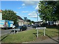
Round House Road, Stoke Aldermoor, Coventry
At the junction with a road called The Moorfield.
Image: © Christine Johnstone
Taken: 24 Sep 2021
0.09 miles
2
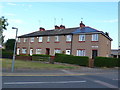
Carter Rd
These social housing houses are in Carter Rd close to the junction with The Moorfield. They are part of Pinley Gardens just south of Lower Stoke.
Image: © Nigel Mykura
Taken: 11 Jun 2011
0.12 miles
3
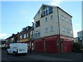
Retail premises on Carter Road, Coventry
Two takeaways and a premier convenience store.
Image: © Christine Johnstone
Taken: 24 Sep 2021
0.14 miles
4
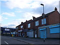
Old Shops Carter Rd
Only one of these shops still appeared to be trading. The others were boarded up
Image: © Nigel Mykura
Taken: 11 Jun 2011
0.14 miles
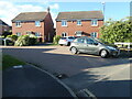
5
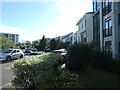
Housing on Paladine Way, Coventry
A new development squeezed in between Carter Road and Pinley House's car park.
Image: © Christine Johnstone
Taken: 24 Sep 2021
0.17 miles
6
Different styles of housing on Sunbeam Way
Recent housing developments in suburban Coventry.
Image: © Christine Johnstone
Taken: 24 Sep 2021
0.17 miles
7
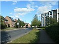
Aldermoor Lane, Lower Stoke, Coventry
Looking northwards, between two styles of housing.
Image: © Christine Johnstone
Taken: 24 Sep 2021
0.18 miles
8
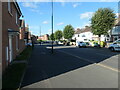
Molesworth Avenue, off Aldermoor Lane, Coventry
This cul-de-sac was planned by 1938, but the houses were not built until after 1945.
Image: © Christine Johnstone
Taken: 24 Sep 2021
0.20 miles
9
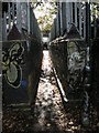
Stoke Aldermoor Footbridge
The extremely narrow footbridge which crosses the Rugby-Coventry line into the Seven Stars Industrial Estate.
Image: © Ian Rob
Taken: 10 Oct 2009
0.21 miles
10
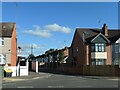
Houses on Yeomanry Walk, Coventry
Off Aldermoor Lane. Built on the site of the Humber car factory.
Image: © Christine Johnstone
Taken: 24 Sep 2021
0.22 miles