IMAGES TAKEN NEAR TO
Juno Drive, LEAMINGTON SPA, CV31 3RG
Introduction
This page details the photographs taken nearby to Juno Drive, CV31 3RG by members of the Geograph project.
The Geograph project started in 2005 with the aim of publishing, organising and preserving representative images for every square kilometre of Great Britain, Ireland and the Isle of Man.

There are currently over 7.5m images from over14,400 individuals and you can help contribute to the project by visiting https://www.geograph.org.uk
Image Map
Images are licensed for reuse under creativecommons.org/licenses/by-sa/2.0
Notes
- Clicking on the map will re-center to the selected point.
- The higher the marker number, the further away the image location is from the centre of the postcode.
Image Listing (50 Images Found)
Images are licensed for reuse under creativecommons.org/licenses/by-sa/2.0
Image
Details
Distance
1
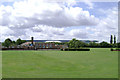
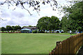
St Patrick's Catholic Primary School, Leamington Spa
Seen from the south end of The Approach across playing fields. Beyond it, on the other side of Queensway, is Spa Park. Prominent in this view is the Aga/Rangemaster building with a footprint of over one hectare (10,000 square metres) It appears on the left of an image of Juno Drive: Image A view of the school from Queensway is: Image
Image: © Robin Stott
Taken: 30 Jul 2009
0.04 miles
2
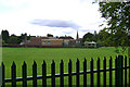
St Patrick's Catholic Primary School, Cashmore Avenue, Leamington Spa
Seen from Queensway. This and the neighbouring Kingsway community school serve the estate centred on Kingsway that was begun by the Corporation in the 1920s on land bought from the Shrubland Hall estate. In the distance is the spire of St John's church, Tachbrook Street Image
Image: © Robin Stott
Taken: 24 Jul 2009
0.04 miles
3
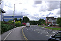
The south end of Queensway, Leamington Spa
OS can't keep pace with all the new businesses and industrial premises, and new roads to serve them, springing up on the site of the huge old Automotive Products works and other industrial estates in south Leamington. On the extreme left is a unit in Jephson Court/Tancred Close. Straight ahead is the rear of Aga/Rangemester off Juno Drive (they have another site pictured in this square). On the right is an estate of shoebox houses - Sapphire Drive and Emerald Way.
Image: © Robin Stott
Taken: 24 Jul 2009
0.06 miles
4
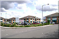
Jephson Court, Tancred Close, Leamington Spa
OS can't keep pace with all the new businesses and industrial premises, and new roads to serve them, springing up on the site of the huge old Automotive Products works and other industrial estates in south Leamington. These units are at the small end of the scale.
Image: © Robin Stott
Taken: 24 Jul 2009
0.10 miles
5
Kingsway Community Primary School, Leamington Spa
Seen here from the south end of The Approach. There is a nursery here also. The trees on the left are on the boundary with Queensway. A view from that direction is: Image
Image: © Robin Stott
Taken: 30 Jul 2009
0.11 miles
6
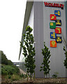
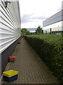
Wolseley, western building, Juno Drive, Leamington Spa
Wolseley is a major distributor of building materials and products, so their facility here is a vast two-part warehouse. This is the north-east corner of the western building, the same as appears in Image Photo taken at normal eye-level.
Image: © Robin Stott
Taken: 28 Jul 2009
0.11 miles
7
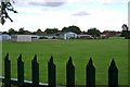
Kingsway Community Primary School, Baker Avenue, Leamington Spa
Seen from Queensway. This and the neighbouring St Patrick's school serve the estate centred on Kingsway that was begun by the Corporation in the 1920s on land bought from the Shrubland Hall estate.
Image: © Robin Stott
Taken: 24 Jul 2009
0.13 miles
8
Smoke from a fire in Hermes Close, south Leamington
During 27 August 2021 it was reported that Warwickshire fire service was dealing with a blaze and explosions at Leeson Polymers. The address given, Juno Drive, was perhaps where the fire service was working from. The company's website was "temporarily closed". Hermes Close is a winding drive serving a number of medium-sized units on an industrial estate off Tachbrook Park Drive. It was later confirmed that a male employee had died in the fire.
Image: © Robin Stott
Taken: 27 Aug 2021
0.13 miles
9
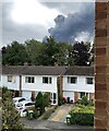
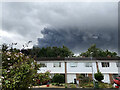
Smoke from a fire in south Leamington
When I first noticed it mid-morning from street level I thought for a moment from the size of it that it was an unusual cloud formation. Photos appeared among NextDoor messages; the Warwick Courier website had a brief report; the BBC Coventry & Warwickshire news page reported that the fire service was dealing with a blaze and explosions at Leeson Polymers. https://www.google.co.uk/maps/@52.2741694,-1.5379557,3a,68.9y,58.25h,85.2t/data=!3m6!1e1!3m4!1sHC-BbKQL4f496vdzgfuUYQ!2e0!7i13312!8i6656?hl=en The address given, Juno Drive, was perhaps where the fire service was working from. The company's website ("temporarily closed") gives its address as Hermes Close, a winding drive serving a number of medium-sized units on an industrial estate off Tachbrook Park Drive.
Image: © Robin Stott
Taken: 27 Aug 2021
0.14 miles
10
The upturn is some way off, Leamington Spa
A view between recently-built business units and factories in Harrison Way, Spa Park. A shocking number of premises in the area are closed, to let or for sale. In the distance is the south side of the very large Aga/Rangemaster building (over a hectare in area). The west side of this building appears on the left of Image
Image: © Robin Stott
Taken: 28 Jul 2009
0.14 miles