IMAGES TAKEN NEAR TO
Adelaide Road, LEAMINGTON SPA, CV31 3PW
Introduction
This page details the photographs taken nearby to Adelaide Road, CV31 3PW by members of the Geograph project.
The Geograph project started in 2005 with the aim of publishing, organising and preserving representative images for every square kilometre of Great Britain, Ireland and the Isle of Man.

There are currently over 7.5m images from over14,400 individuals and you can help contribute to the project by visiting https://www.geograph.org.uk
Image Map (Loading...)


Getting Data...Please wait
Leaflet Map data © OpenStreetMap
Images are licensed for reuse under creativecommons.org/licenses/by-sa/2.0
Notes
- Clicking on the map will re-center to the selected point.
- The higher the marker number, the further away the image location is from the centre of the postcode.
Image Listing (859 Images Found)
Images are licensed for reuse under creativecommons.org/licenses/by-sa/2.0
Image
Details
Distance
1
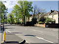
Villas and lime trees, Adelaide Road, Leamington
There were plans for this southwest area of the town in the 1840s but it was only later that any development took place. In 1850 Adelaide Bridge replaced the flood-prone Dale Street bridge suggesting that Adelaide Road itself had gained in importance as a route to both the Avenue Road and Milverton railway stations. Brunel's Oxford to Birmingham extension of the GWR reached Leamington in 1852. The spa town became a residential town, home to businessmen who commuted to Birmingham and Coventry. Not until the 1860s and 70s do town plans show the cluster of large elegant villas in Adelaide and Avenue Roads Image
Image: © Robin Stott
Taken: 19 Apr 2020
0.02 miles
2
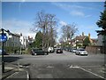
View north up Adelaide Road, Royal Leamington Spa
Adelaide Road villas appear in street directories from the later 1860s, a surprising 15 years after the rebuilding of Adelaide Bridge across the widened River Leam following a flood. The previous bridge was named after the dowager Queen Adelaide in honour of her visit to the town in 1839. The development of Adelaide Road and Avenue Road, off to the right, is closer in date to the opening of the New River Walk. It may also reflect Leamington's slow change from resort to a residential town with good rail connections. The view is from the western mouth of Station Approach, which served the L&NWR's Avenue Road station.
Image: © Robin Stott
Taken: 11 Mar 2013
0.02 miles
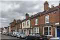
3
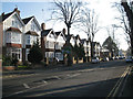
Three-storey houses, south end of Adelaide Road
Image: © Robin Stott
Taken: 15 Jan 2012
0.03 miles
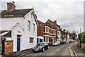
4
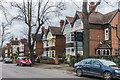
Adelaide Road
A row of late 19th Century or early 20th Century houses.
Image: © Ian Capper
Taken: 4 Mar 2017
0.03 miles
5
The River Leam
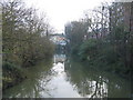
Looking east from York Road Footbridge, with the tower and roof of the Parish Church visible over the trees.
Image: © David Stowell
Taken: 10 Dec 2005
0.03 miles
6
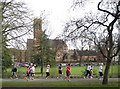
Regency 10K 2010: 11
Runners in York Promenade are nearing the last kilometre of the course, against a background of the Pump Room Gardens and St Peter's Church. 9:57am.
Image: © Robin Stott
Taken: 11 Apr 2010
0.03 miles
7
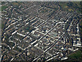
Leamington Spa from the air
The grid pattern of the streets in the older part of the town is evident, as is the presence of many white coloured buildings. Viewed from a Birmingham bound flight from Prague.
Image: © Thomas Nugent
Taken: 11 Feb 2022
0.03 miles
8
9 Victoria Street
A 19th Century terraced house in Victoria Street. The blue plaque commemorates this once being the home of Sir Frank Whittle, inventor of the jet engine, who spent much of his childhood in Leamington Spa.
For a wider view see Image - no 9 is towards the left of the photo, immediately to the right of the taller building with bay windows.
Image: © Ian Capper
Taken: 4 Mar 2017
0.04 miles
9
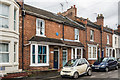
Victoria Street
A road of mainly 19th Century terraced housing.
Image: © Ian Capper
Taken: 4 Mar 2017
0.04 miles
10
Victoria Street
A road of mainly 19th Century terraced housing.
Image: © Ian Capper
Taken: 4 Mar 2017
0.04 miles