IMAGES TAKEN NEAR TO
Kingsway, LEAMINGTON SPA, CV31 3LN
Introduction
This page details the photographs taken nearby to Kingsway, CV31 3LN by members of the Geograph project.
The Geograph project started in 2005 with the aim of publishing, organising and preserving representative images for every square kilometre of Great Britain, Ireland and the Isle of Man.

There are currently over 7.5m images from over14,400 individuals and you can help contribute to the project by visiting https://www.geograph.org.uk
Image Map (Loading...)


Getting Data...Please wait
Leaflet Map data © OpenStreetMap
Images are licensed for reuse under creativecommons.org/licenses/by-sa/2.0
Notes
- Clicking on the map will re-center to the selected point.
- The higher the marker number, the further away the image location is from the centre of the postcode.
Image Listing (158 Images Found)
Images are licensed for reuse under creativecommons.org/licenses/by-sa/2.0
Image
Details
Distance
1
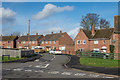
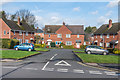
Edinburgh Crescent
1940s(?) housing built in the former grounds of the now demolished Shrubland Hall.
Image: © Ian Capper
Taken: 4 Mar 2017
0.02 miles
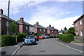
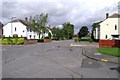
2
Edinburgh Crescent, Leamington Spa
On the north side of Kingsway on the Shrublands estate.
Image: © Robin Stott
Taken: 30 Jul 2009
0.04 miles
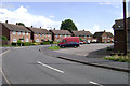
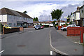
3
Lower end of Kingsway, Leamington Spa
The principal route that bisects the Shrublands estate, near its junction with Tachbrook Road.
Image: © Robin Stott
Taken: 30 Jul 2009
0.05 miles
4
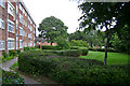
Maxstoke Gardens, Tachbrook Road, Leamington Spa
One of two instances of council flats whose grounds were landscaped with sinuous hedges. The name refers to Maxstoke Castle in north Warwickshire.
Image: © Robin Stott
Taken: 30 Jul 2009
0.05 miles
5
Viscount Close
1940s(?) housing built in the grounds of the now demolished Shrubland Hall.
Image: © Ian Capper
Taken: 4 Mar 2017
0.06 miles
6
Lee Road, Leamington Spa
Seen from the corner of Turpin Court, whose name commemorates the boxer Randolph Turpin. He was born in Leamington and became World Middleweight Champion in 1951.
Image: © Robin Stott
Taken: 30 Jul 2009
0.09 miles
7
Summit of Kennan Avenue, Leamington
Near its junction with Swadling Street, indicated by the white house, right.
Image: © Robin Stott
Taken: 30 Jul 2009
0.09 miles
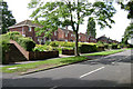
8
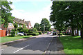
Nevill Close, Leamington Spa
One of the leafier streets on the Shrublands estate.
Image: © Robin Stott
Taken: 30 Jul 2009
0.10 miles
9
The Approach, Leamington Spa
Near its junction with Elizabeth Road, left, and Nevill Close, right. Kingsway beyond.
Image: © Robin Stott
Taken: 30 Jul 2009
0.10 miles
10
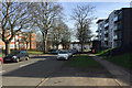
East end of Kingsway, south Leamington
Ahead, modest 19th-century houses on Tachbrook Road. To the left, Maxstoke Gardens, older low-rise council flats. To the right, Sayer Court, new council-built flats for the over-55s for rent not for sale; 81 flats in all and five bungalows for people of any age with a disability. The site was formerly an older council property, Fetherston Court, part-seen in Image The trees are mostly Tree of Heaven (Ailanthus altissima).
Image: © Robin Stott
Taken: 13 Mar 2017
0.10 miles