IMAGES TAKEN NEAR TO
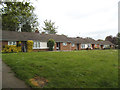
Sargeaunt Street, LEAMINGTON SPA, CV31 3HS
Introduction
This page details the photographs taken nearby to Sargeaunt Street, CV31 3HS by members of the Geograph project.
The Geograph project started in 2005 with the aim of publishing, organising and preserving representative images for every square kilometre of Great Britain, Ireland and the Isle of Man.

There are currently over 7.5m images from over14,400 individuals and you can help contribute to the project by visiting https://www.geograph.org.uk
Image Map
Images are licensed for reuse under creativecommons.org/licenses/by-sa/2.0
Notes
- Clicking on the map will re-center to the selected point.
- The higher the marker number, the further away the image location is from the centre of the postcode.
Image Listing (631 Images Found)
Images are licensed for reuse under creativecommons.org/licenses/by-sa/2.0
Image
Details
Distance
1
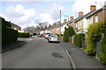
The summit of Bury Road
An old estate of small semi-detached council houses, many of which have been extended and refurbished.
Image: © Robin Stott
Taken: 7 Apr 2009
0.05 miles
2
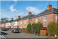
Bury Road
1930s housing built in the grounds of the now demolished Shrubland Hall.
Image: © Ian Capper
Taken: 4 Mar 2017
0.05 miles
3
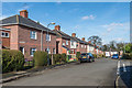
Kennan Avenue
1930s housing built in the grounds of the now demolished Shrubland Hall.
Image: © Ian Capper
Taken: 4 Mar 2017
0.05 miles
4
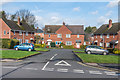
Viscount Close
1940s(?) housing built in the grounds of the now demolished Shrubland Hall.
Image: © Ian Capper
Taken: 4 Mar 2017
0.08 miles
6
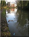
Rubbish in the canal near Station House, Leamington
In contrast to the weak-kneed Old Warwick Road frontage Image, this block looks like something out of a business park.
Image: © Robin Stott
Taken: 24 Dec 2013
0.09 miles
7
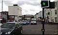
High Street, Leamington Spa
The name High Street dates from the time when the village of Leamington Priors was developing as a fashionable spa south of the river. When the New Town north of the river outpaced the Old Town, the name High Street became an anachronism. It is still one of Leamington's busiest roads.
Image: © Robin Stott
Taken: 5 Apr 2009
0.09 miles
8
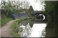
Grand Union Canal, Leamington Spa
A cruising canal boat passes under Tachbrook Road bridge.
Image: © Robin Stott
Taken: 5 Apr 2009
0.09 miles
9
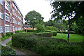
Maxstoke Gardens, Tachbrook Road, Leamington Spa
One of two instances of council flats whose grounds were landscaped with sinuous hedges. The name refers to Maxstoke Castle in north Warwickshire.
Image: © Robin Stott
Taken: 30 Jul 2009
0.09 miles
10
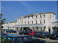
Leamington Spa Station
This is the former Leamington Spa (General) Station on the main GWR London - Birmingham Line. The station was rebuilt between 1936 and 1939 and was only just completed as WWII broke out. Today the station enjoys frequent services to Birmingham, Coventry, London Marylebone, and the South East.
Image: © David Stowell
Taken: 9 Jul 2005
0.10 miles