IMAGES TAKEN NEAR TO
Harrison Way, LEAMINGTON SPA, CV31 3HJ
Introduction
This page details the photographs taken nearby to Harrison Way, CV31 3HJ by members of the Geograph project.
The Geograph project started in 2005 with the aim of publishing, organising and preserving representative images for every square kilometre of Great Britain, Ireland and the Isle of Man.

There are currently over 7.5m images from over14,400 individuals and you can help contribute to the project by visiting https://www.geograph.org.uk
Image Map
Images are licensed for reuse under creativecommons.org/licenses/by-sa/2.0
Notes
- Clicking on the map will re-center to the selected point.
- The higher the marker number, the further away the image location is from the centre of the postcode.
Image Listing (51 Images Found)
Images are licensed for reuse under creativecommons.org/licenses/by-sa/2.0
Image
Details
Distance
1
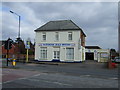
Jephson Court, Tancred Close, Leamington Spa
OS can't keep pace with all the new businesses and industrial premises, and new roads to serve them, springing up on the site of the huge old Automotive Products works and other industrial estates in south Leamington. These units are at the small end of the scale.
Image: © Robin Stott
Taken: 24 Jul 2009
0.04 miles
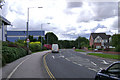
2
East end of Harrison Way, Leamington Spa
Leading into Spa Park from Tachbrook Road.
Image: © Richard Vince
Taken: 4 Mar 2017
0.05 miles
3
Harrison Way
Looking back to the entrance to the Spa Park Industrial Estate. The estate is dominated by Woolsley.
Image: © David Lally
Taken: 8 Apr 2009
0.07 miles
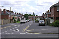
4
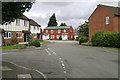
Windmill Road, Leamington Spa
A residential cul de sac off Tachbrook Road.
Image: © Richard Vince
Taken: 4 Mar 2017
0.07 miles
5
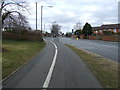
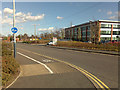
Cycle path beside the B4087
Heading north into Leamington Spa.
Image: © JThomas
Taken: 4 Apr 2013
0.08 miles
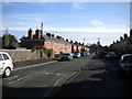
6
Windmill Road, Leamington Spa
Old photographs show a windmill further down Tachbrook Road (off to the right). It was finally demolished in 1968 but is remembered in the names of this road and the Windmill Inn. The trees in the background are in Leamington Cemetery, Brunswick Street Image mostly.
Image: © Robin Stott
Taken: 30 Jul 2009
0.09 miles
7
The south end of Queensway, Leamington Spa
OS can't keep pace with all the new businesses and industrial premises, and new roads to serve them, springing up on the site of the huge old Automotive Products works and other industrial estates in south Leamington. On the extreme left is a unit in Jephson Court/Tancred Close. Straight ahead is the rear of Aga/Rangemester off Juno Drive (they have another site pictured in this square). On the right is an estate of shoebox houses - Sapphire Drive and Emerald Way.
Image: © Robin Stott
Taken: 24 Jul 2009
0.09 miles
8
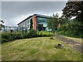
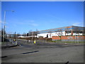
Aura building, Precision Park, south Leamington
At the time of the photo the former high-quality HQ building for Wolseley UK (Ferguson plc elsewhere) had been refurbished as a suite of business premises by the property developers Canmoor and others. Access is from Harrison Way, the main entrance to the Spa Park industrial estate, of which Precision Park may be a corner renamed. The photo is a view from Tachbrook Road.
Image: © Robin Stott
Taken: 24 May 2022
0.09 miles
9
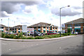
Brakesmead, Leamington Spa
This small estate was developed, controversially, on the home ground of a local football team, Leamington Brakes. They were sponsored by major local employer Lockheed Hydraulic Brakes (later known as Automotive Products or AP) and remembered in the name Lockheed Close, behind the camera. Brakesmead is a turning off Culworth Close, centre.
Image: © Robin Stott
Taken: 30 Jul 2009
0.10 miles