IMAGES TAKEN NEAR TO
Antony Gardner Crescent, LEAMINGTON SPA, CV31 2TQ
Introduction
This page details the photographs taken nearby to Antony Gardner Crescent, CV31 2TQ by members of the Geograph project.
The Geograph project started in 2005 with the aim of publishing, organising and preserving representative images for every square kilometre of Great Britain, Ireland and the Isle of Man.

There are currently over 7.5m images from over14,400 individuals and you can help contribute to the project by visiting https://www.geograph.org.uk
Image Map
Images are licensed for reuse under creativecommons.org/licenses/by-sa/2.0
Notes
- Clicking on the map will re-center to the selected point.
- The higher the marker number, the further away the image location is from the centre of the postcode.
Image Listing (57 Images Found)
Images are licensed for reuse under creativecommons.org/licenses/by-sa/2.0
Image
Details
Distance
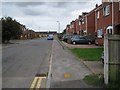
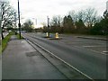
1
Greenspace off Montgomery Road, Whitnash
A new public open space provided under a planning agreement. It serves new residential development on the site of the extensive South Leamington private allotments. Rear of Antony Gardner Crescent, left.
Image: © Robin Stott
Taken: 21 Aug 2009
0.02 miles
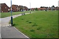
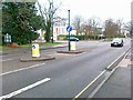
2
Henrys Way, end of Dobson Lane, Whitnash
A route between new housing estate and existing primary school. Aaarrgh, those chicanes! But I suppose they're designed to be difficult for motorbikes.
Image: © Robin Stott
Taken: 21 Aug 2009
0.07 miles
3
Houses on Tachbrook Road seen across an unnamed brook, Whitnash
The view is from a shared path leading into the new development of small industrial units at the end of Poseidon Way Image, now known as the Trident Business Centre.
Image: © Robin Stott
Taken: 29 Dec 2015
0.07 miles

7
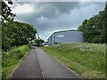
Leafy start to a footpath and cycleway, Trident Park, south Leamington
The nearest unit is for Presto Music, who have a shop in the town centre https://www.prestomusic.com/shop
Here's how the scene looked in 2015 Image
Image: © Robin Stott
Taken: 24 May 2022
0.11 miles
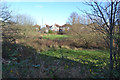
8
Vacant site, end of Dobson Lane, Whitnash
Until the early 1980s this was part of Leamington Cemetery's southern, unfilled, extension. Then it was laid out as Whitnash Community Allotments but they were not a success for various reasons. From the jungle it became the site has been somewhat tamed. There has been talk of more housing, or a sports hall on the site. Given the projected increase in population for south Warwickshire it might be wise if the land reverted to cemetery extension.
Image: © Robin Stott
Taken: 21 Aug 2009
0.12 miles
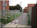
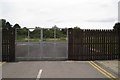
9

Shared path between Tachbrook Road and the Trident Business Centre, Whitnash
The Trident Business Centre consists of small industrial units at the end of Poseidon Way Image Ahead, the postcode area changes to CV34.
Image: © Robin Stott
Taken: 29 Dec 2015
0.12 miles