IMAGES TAKEN NEAR TO
Grayling Crescent, LEAMINGTON SPA, CV31 1DD
Introduction
This page details the photographs taken nearby to Grayling Crescent, CV31 1DD by members of the Geograph project.
The Geograph project started in 2005 with the aim of publishing, organising and preserving representative images for every square kilometre of Great Britain, Ireland and the Isle of Man.

There are currently over 7.5m images from over14,400 individuals and you can help contribute to the project by visiting https://www.geograph.org.uk
Image Map
Images are licensed for reuse under creativecommons.org/licenses/by-sa/2.0
Notes
- Clicking on the map will re-center to the selected point.
- The higher the marker number, the further away the image location is from the centre of the postcode.
Image Listing (55 Images Found)
Images are licensed for reuse under creativecommons.org/licenses/by-sa/2.0
Image
Details
Distance
1
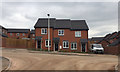
Short terrace of three houses, Admiral Way, Upper Sydenham, south Leamington
Near Image All the roads are named after butterflies.
Image: © Robin Stott
Taken: 28 Apr 2017
0.05 miles
2
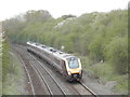
Whitnash railway cutting
This deep cutting is on the ex-GWR line from Leamington Spa to Banbury. Although not as deep as that at Harbury, about 3 miles further south, it is, nevertheless, extensive.
Image: © Barry Bolland
Taken: 21 Apr 2016
0.09 miles
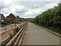
3
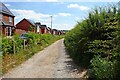
Whitnash Bridleway
Running along the side of a newish housing development.
Image: © Ian Rob
Taken: 14 Jun 2021
0.09 miles
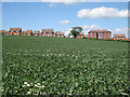
4
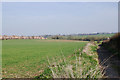
How long...?
An encroaching wave of new housing threatens to engulf this farmland at Whitnash, Leamington Spa. Perhaps the recession will save it for a few more years.
Image: © Colin Craig
Taken: 20 Mar 2009
0.09 miles
5
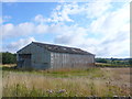
Barn near Whitnash
The eastern boundary of the southern side of Leamington Spa is defdined by the Leamington to Banbury railway line. on the east side of the track is this farmland. This barn is next to the bridge where the track to Radford Barn and Barn Farm crosses the railway.
Image: © Nigel Mykura
Taken: 28 Aug 2011
0.11 miles
6
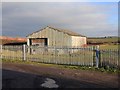
Barn near bridleway to Radford Semele
Just east of the railway bridge at the end of Church Lane is this large barn or storage shed.
Image: © David P Howard
Taken: 5 Dec 2010
0.11 miles
8
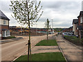
New estate in Upper Sydenham, Whitnash
Looking down Admiral Way towards the Whitnash Brook valley. All the roads on this estate are named after butterflies. The developer is A.C.Lloyd, a local firm. This was a greenfield site, part of Green Farm, Whitnash: see Image from 2009, and Image from 2010.
Image: © Robin Stott
Taken: 28 Apr 2017
0.11 miles
10
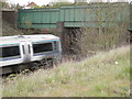
Railway bridge, Church Lane, Whitnash
This bridge, at the southern end of Whitnash Cutting, carries a bridleway over the ex-GWR line from Leamington Spa to Banbury. The train is en route to Birmingham.
Image: © Barry Bolland
Taken: 21 Apr 2016
0.12 miles