IMAGES TAKEN NEAR TO
Hermitage Road, COVENTRY, CV2 5GG
Introduction
This page details the photographs taken nearby to Hermitage Road, CV2 5GG by members of the Geograph project.
The Geograph project started in 2005 with the aim of publishing, organising and preserving representative images for every square kilometre of Great Britain, Ireland and the Isle of Man.

There are currently over 7.5m images from over14,400 individuals and you can help contribute to the project by visiting https://www.geograph.org.uk
Image Map
Images are licensed for reuse under creativecommons.org/licenses/by-sa/2.0
Notes
- Clicking on the map will re-center to the selected point.
- The higher the marker number, the further away the image location is from the centre of the postcode.
Image Listing (6 Images Found)
Images are licensed for reuse under creativecommons.org/licenses/by-sa/2.0
Image
Details
Distance
1

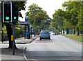
A4600 Ansty Road at Church End, Coventry
Image: © Mat Fascione
Taken: 7 Nov 2020
0.12 miles
2
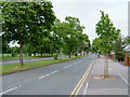
A4600 Ansty Road
Heading towards Coventry city centre.
Image: © Mat Fascione
Taken: 11 Sep 2014
0.15 miles
3
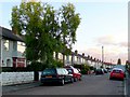
Newey Rd
This residential road runs parallel to the Ansty Rd and is just south of it. This is the view west from close to the junction with Cowley Rd
Image: © Nigel Mykura
Taken: 18 Aug 2010
0.22 miles
4
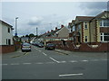
Ansty Road
Looking along Ansty Rd to the North East. M6 Junction 2 is about 2 1/2 miles away.
To the left is the playing field known locally as The Annexe
Image: © Kevin Croucher
Taken: 13 Jun 2005
0.23 miles
5
Coventry-Coleridge Road
Looking from Longfellow Road.
Image: © Ian Rob
Taken: 24 Jun 2011
0.25 miles
6
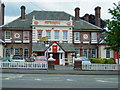
The Walsgrave
Large Pub and Carvery on the Corner of Walsgrave Road and Ansty Road
Image: © Kevin Croucher
Taken: 13 Jun 2005
0.25 miles