IMAGES TAKEN NEAR TO
Heath Crescent, COVENTRY, CV2 4PS
Introduction
This page details the photographs taken nearby to Heath Crescent, CV2 4PS by members of the Geograph project.
The Geograph project started in 2005 with the aim of publishing, organising and preserving representative images for every square kilometre of Great Britain, Ireland and the Isle of Man.

There are currently over 7.5m images from over14,400 individuals and you can help contribute to the project by visiting https://www.geograph.org.uk
Image Map
Images are licensed for reuse under creativecommons.org/licenses/by-sa/2.0
Notes
- Clicking on the map will re-center to the selected point.
- The higher the marker number, the further away the image location is from the centre of the postcode.
Image Listing (25 Images Found)
Images are licensed for reuse under creativecommons.org/licenses/by-sa/2.0
Image
Details
Distance
1
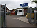
Stoke Heath Children's Centre, Heath Crescent
Image: © John Brightley
Taken: 25 May 2010
0.04 miles
2
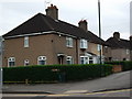
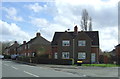
Houses on corner of Wyken Way and Heath Crescent, Stoke Heath
Part of the Stoke Heath 'garden suburb' of council houses built in the 1920's/30's.
Note the old 'Wyken Way' road sign.
Image: © John Brightley
Taken: 25 May 2010
0.07 miles
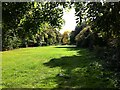
3
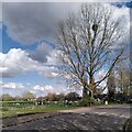
Poplar tree with mistletoe, Stoke Heath, Coventry
This poplar is growing by the children's play area near the junction of Heath Crescent, the road in the foreground, and Valley Road, the houses of which can be seen in the distance. Stoke Heath, a large green and recreation ground, is off to the left. The poplar was just coming into leaf.
Image: © A J Paxton
Taken: 30 Mar 2024
0.09 miles
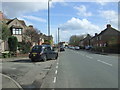
4
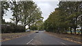
Towards Stoke Heath
The road towards Stoke Heath from the A444 in Coventry.
Image: © Peter Mackenzie
Taken: 2 Oct 2018
0.13 miles
5
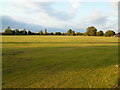
Stoke Heath
A valuable open space in a rather run down part of Coventry
Image: © Kevin Croucher
Taken: 13 Jun 2005
0.16 miles
6
Stoke Heath looking towards Barras Heath
This narrow strip of land between modern housing developments connects Stoke Heath to the north with Barras Heath to the south; all are now modern recreation grounds with no trace of heathland.
Image: © A J Paxton
Taken: 1 Oct 2022
0.17 miles
8
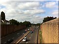
A444 Jimmy Hill Way, looking north from Swancroft Road bridge
This section of the A444 was built in the 1990s, much of it along the route of a disused railway. Originally named Phoenix Way, it was renamed after the former footballer, Coventry City FC manager and TV sports commentator Jimmy Hill after his death in 2015.
Image: © A J Paxton
Taken: 26 Aug 2021
0.22 miles
10
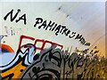
Lovers rising above the fray
Graffiti covers the wall above the towpath of the Coventry Canal where it enters the northern end of the tunnel under Waterman Road by its junction with Jimmy Hill Way. Above the mass of shapes is Polish graffiti offering itself as a souvenir of lovers' trysts.
Image: © A J Paxton
Taken: 17 Jul 2022
0.23 miles