IMAGES TAKEN NEAR TO
Gleneagles Road, COVENTRY, CV2 3BB
Introduction
This page details the photographs taken nearby to Gleneagles Road, CV2 3BB by members of the Geograph project.
The Geograph project started in 2005 with the aim of publishing, organising and preserving representative images for every square kilometre of Great Britain, Ireland and the Isle of Man.

There are currently over 7.5m images from over14,400 individuals and you can help contribute to the project by visiting https://www.geograph.org.uk
Image Map
Images are licensed for reuse under creativecommons.org/licenses/by-sa/2.0
Notes
- Clicking on the map will re-center to the selected point.
- The higher the marker number, the further away the image location is from the centre of the postcode.
Image Listing (15 Images Found)
Images are licensed for reuse under creativecommons.org/licenses/by-sa/2.0
Image
Details
Distance
1

Grey Poplar leaves and bark, Sowe Valley, upstream from Clifford Bridge, Coventry
Populus x canescens is the scientific name of Grey Poplar, a colossal tree. Although late June, the grey-white felted undersides of the leaves can be seen; also the distinctive diamond-shaped pits in the pale bark of the upper bole. The hybrid nature of the tree (White Poplar, Populus alba x Aspen, Populus tremula) is reflected in the shape of the wavy-edged round leaves.
Image: © Robin Stott
Taken: 27 Jun 2016
0.10 miles
2
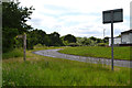
Sharp bend on Hermes Crescent, Wyken, Coventry
Hermes Crescent exhibits a mix of housing types. The Sowe Valley footpath connects with it. Among the trees the River Sowe meanders through the northern side of Wyken Croft Nature Park, a former coal-mining site.
Image: © Robin Stott
Taken: 27 Jun 2016
0.14 miles
3
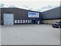
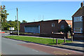
Unit, Henley Industrial Park, Coventry
At the far southeast corner of the site, the photographer's destination: to collect a router ordered by his daughter.
Image: © Robin Stott
Taken: 8 Jun 2022
0.15 miles
4

South in Henley Industrial Park
The site extends south to the edge of open space on the north bank of the River Sowe Image
Image: © Robin Stott
Taken: 8 Jun 2022
0.15 miles
5
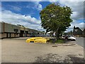
North in Henley Industrial Park, Coventry
Looking back towards the entrance on Henley Road.
Image: © Robin Stott
Taken: 8 Jun 2022
0.17 miles

7

North in Henley Industrial Park, Coventry
Looking back towards the entrance on Henley Road. The landscaping goes its own way where it can.
Image: © Robin Stott
Taken: 8 Jun 2022
0.22 miles
8
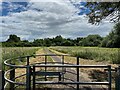
Footpath into Potter's Green Corridor, Henley Green, Coventry
The River Sowe runs among the trees. Behind the camera is Henley Road.
Image: © Robin Stott
Taken: 8 Jun 2022
0.22 miles
9
Telephone exchange, corner of Ansty Road and Clifford Bridge Road, Coventry
Image: © Robin Stott
Taken: 1 Oct 2015
0.23 miles
10
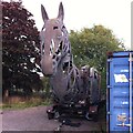
Godiva's iron steed
Godiva's iron horse has been put out to grass, or asphalt, on an industrial estate on Henley Road. The horse, and the fifty seat cycle that powered it, were built by Imagineer to transport a giant puppet of Lady Godiva from Coventry to London for the Cultural Olympiad that accompanied the London Olympic Games of 2012. For more information see the Imagineer site https://imagineer-productions.co.uk/projects/godiva-awakes/ . Horse and puppet can be seen in Broadgate in central Coventry here Image
Image: © A J Paxton
Taken: 9 Oct 2022
0.23 miles