IMAGES TAKEN NEAR TO
Main Street, RUGBY, CV23 0PF
Introduction
This page details the photographs taken nearby to Main Street, CV23 0PF by members of the Geograph project.
The Geograph project started in 2005 with the aim of publishing, organising and preserving representative images for every square kilometre of Great Britain, Ireland and the Isle of Man.

There are currently over 7.5m images from over14,400 individuals and you can help contribute to the project by visiting https://www.geograph.org.uk
Image Map
Images are licensed for reuse under creativecommons.org/licenses/by-sa/2.0
Notes
- Clicking on the map will re-center to the selected point.
- The higher the marker number, the further away the image location is from the centre of the postcode.
Image Listing (7 Images Found)
Images are licensed for reuse under creativecommons.org/licenses/by-sa/2.0
Image
Details
Distance
1
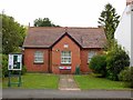
Stretton Under Fosse Village Hall
On Main St.
Image: © Ian Rob
Taken: 16 May 2017
0.02 miles
2

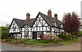
The Old Forge, Stretton under Fosse
The Old Forge on Main Street dates from the early 17th century although part of it has possibly been rebuilt. It is grade II listed. The bus stop is on the Coventry - Rugby via Brinklow service.
Image: © Stephen McKay
Taken: 30 Dec 2020
0.03 miles
3
Stretton Under Fosse-The Old Forge
Grade II Listed house on Main Street.
Image: © Ian Rob
Taken: 16 May 2017
0.03 miles
4
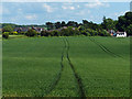
Stretton under Fosse
Looking southeast from the Fosse Way towards the village.
Image: © Mat Fascione
Taken: 5 Jun 2014
0.07 miles
5
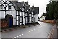
Main Street, Stretton under Fosse
Stretton under Fosse is not on the Fosse Way itself which is located about half a mile to the west. This is the view along Main Street with the grade II listed 16th century Home Farmhouse on the left.
Image: © Stephen McKay
Taken: 30 Dec 2020
0.10 miles
6
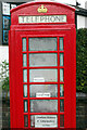
Stretton History and Information Centre
Many villages have found new uses for their redundant telephone boxes; typically they now house defibrillators or book exchanges. Stretton under Fosse has done something different and created a history and information centre. Inside the classic K6 box there is a map and an illustrated book describing the history of the village and immediate area - an imaginative and worthwhile idea.
Image: © Stephen McKay
Taken: 30 Dec 2020
0.11 miles