IMAGES TAKEN NEAR TO
Post Office Yard, The Crescent, RUGBY, CV23 0LH
Introduction
This page details the photographs taken nearby to Post Office Yard, The Crescent, CV23 0LH by members of the Geograph project.
The Geograph project started in 2005 with the aim of publishing, organising and preserving representative images for every square kilometre of Great Britain, Ireland and the Isle of Man.

There are currently over 7.5m images from over14,400 individuals and you can help contribute to the project by visiting https://www.geograph.org.uk
Image Map
Images are licensed for reuse under creativecommons.org/licenses/by-sa/2.0
Notes
- Clicking on the map will re-center to the selected point.
- The higher the marker number, the further away the image location is from the centre of the postcode.
Image Listing (54 Images Found)
Images are licensed for reuse under creativecommons.org/licenses/by-sa/2.0
Image
Details
Distance
1
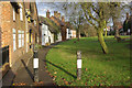
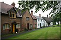
The Crescent, Brinklow
Possibly the most attractive part of the village, opposite the church.
Image: © Stephen McKay
Taken: 2 Dec 2007
0.02 miles
4
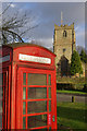
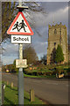
Brinklow Church and Telephone Box
Brinklow Church is dedicated to St John the Baptist; it was rebuilt in the 15th century although there are some remains of the earlier building. The K6 telephone box appears to be in need of some care and attention.
Image: © Stephen McKay
Taken: 2 Dec 2007
0.04 miles
5
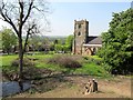
Brinklow Church
The church, dedicated to St John the Baptist, stands alongside the main road through the village, here called The Crescent. The road was formerly the A427, but has now been downgraded to the B4027. This is also, in effect, part of the Fosse Way although the original course of the Roman road ran slightly to the east of here and has now been obliterated.
Image: © Stephen McKay
Taken: 2 Dec 2007
0.04 miles
6
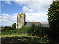
Church of St. John the Baptist, Brinklow
Seen from the bailey of the onetime Brinklow Castle.
Image: © Jonathan Thacker
Taken: 16 Sep 2016
0.05 miles
7
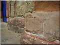
Benchmark on Brinklow Church
This benchmark was established in 1856 during the First primary levelling of England & Wales, and was levelled with a height of 330.9680 feet [100.8790 metres] above mean sea level (Liverpool datum). It was included on the Coventry to Lincoln levelling line. The surveyor's description was "No. 14. Bolt in South-west angle of Brinklow Church tower ; 2.89 ft. above surface" (Public Abstract p.326).
Image: © Shantavira
Taken: 23 May 2015
0.05 miles
8
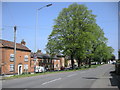
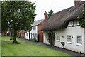
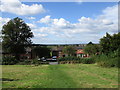
Brinklow-The Crescent
Cottages set back from the Main Road.
Image: © Ian Rob
Taken: 7 May 2008
0.05 miles
9
View from the bailey of Brinklow Castle
Looking down to The Crescent.
Image: © Jonathan Thacker
Taken: 16 Sep 2016
0.05 miles
10
Brinklow Church of Saint John the Baptist
Looking from the site of the Norman Castle towards Broad Street.
Image: © Ian Rob
Taken: 22 May 2012
0.05 miles