IMAGES TAKEN NEAR TO
Harborough Parva, Harborough Magna, RUGBY, CV23 0HW
Introduction
This page details the photographs taken nearby to CV23 0HW by members of the Geograph project.
The Geograph project started in 2005 with the aim of publishing, organising and preserving representative images for every square kilometre of Great Britain, Ireland and the Isle of Man.

There are currently over 7.5m images from over14,400 individuals and you can help contribute to the project by visiting https://www.geograph.org.uk
Image Map
Images are licensed for reuse under creativecommons.org/licenses/by-sa/2.0
Notes
- Clicking on the map will re-center to the selected point.
- The higher the marker number, the further away the image location is from the centre of the postcode.
Image Listing (8 Images Found)
Images are licensed for reuse under creativecommons.org/licenses/by-sa/2.0
Image
Details
Distance
1
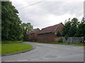
Harborough Parva
Farm buildings on Easenhall Lane
Image: © Ian Rob
Taken: 5 Jun 2007
0.04 miles
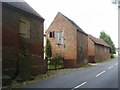
2

Easenhall Road, Harborough Parva
Autumn sunshine dapples the old farm buildings on the north side of Easenhall Road.
Image: © Stephen McKay
Taken: 10 Oct 2010
0.04 miles
3
Harborough Parva-Easenhall Road
Old Farm buildings.
Image: © Ian Rob
Taken: 31 Jul 2011
0.05 miles
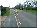
4
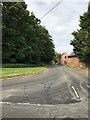
Easenhall Road junction in Harborough Magna
Image: © Dave Thompson
Taken: 9 Jun 2020
0.05 miles
5
Harborough Parva
Farm Buildings on the footpath from Cosford.
Image: © Ian Rob
Taken: 28 Jun 2007
0.17 miles
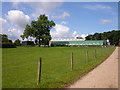
7
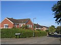
Harborough Magna
Although this is an ancient village it is close to Rugby and has seen much expansion with modern housing in recent years.
Image: © David Stowell
Taken: 24 Sep 2005
0.20 miles
8

Harborough Parva
Looking along the footpath to Cosford.
Image: © Ian Rob
Taken: 28 Jun 2007
0.24 miles