IMAGES TAKEN NEAR TO
Marnhull Close, COVENTRY, CV2 2JS
Introduction
This page details the photographs taken nearby to Marnhull Close, CV2 2JS by members of the Geograph project.
The Geograph project started in 2005 with the aim of publishing, organising and preserving representative images for every square kilometre of Great Britain, Ireland and the Isle of Man.

There are currently over 7.5m images from over14,400 individuals and you can help contribute to the project by visiting https://www.geograph.org.uk
Image Map
Images are licensed for reuse under creativecommons.org/licenses/by-sa/2.0
Notes
- Clicking on the map will re-center to the selected point.
- The higher the marker number, the further away the image location is from the centre of the postcode.
Image Listing (60 Images Found)
Images are licensed for reuse under creativecommons.org/licenses/by-sa/2.0
Image
Details
Distance
1
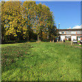
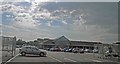
Open space beside the Dorchester Way estate, Walsgrave, Coventry
The open space is a buffer between the residential area and Clifford Bridge Road. The footpath, right, is a well-trodden route to and from University Hospital.
Image: © Robin Stott
Taken: 20 Oct 2015
0.06 miles
2
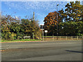
A hedgerow stops at the lights, Clifford Bridge Road, Walsgrave, Coventry
This is the junction with Belgrave Road, out of shot right. The colourful Norway Maple, right of centre, and the big oak, right, are a sign of a maturing residential estate built on former countryside. A footpath emerges from the open space opposite and continues by the road, guarded by the (bashed) railing, while the hole in the hedge, left, speaks of a pedestrian desire line unrecognised by authority. The truncated hedge adds to the picture of a road junction that has been remodelled to increase capacity, imposing a safe way for people on foot, even perhaps as the result of an accident.
Image: © Robin Stott
Taken: 28 Oct 2015
0.11 miles
4
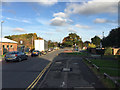
Looking east on Belgrave Road, Walsgrave, Coventry
Traffic queues at the junction with Clifford Bridge Road. Dalton Gardens is the turning on the right.
Image: © Robin Stott
Taken: 28 Oct 2015
0.13 miles
5
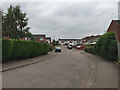
Blandford Drive, Walsgrave, Coventry
A turning off Dorchester Way.
Image: © Robin Stott
Taken: 15 Oct 2015
0.14 miles
6
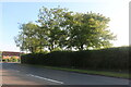
South on the footpath on the west side of Clifford Bridge Road, Walsgrave, Coventry
The path is pleasantly separated from Clifford Bridge Road by the planting, left. The green grass, lower right, is an open space to the south of two-storey houses in Keswick Walk.
Image: © Robin Stott
Taken: 28 Oct 2015
0.15 miles
7
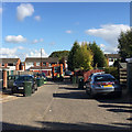
Bin day, Dorchester Way, Walsgrave, Coventry
Image: © Robin Stott
Taken: 20 Oct 2015
0.16 miles
10
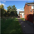
Footpath alongside the Dorchester Way estate, Walsgrave, Coventry
It's a route to and from University Hospital.
Image: © Robin Stott
Taken: 20 Oct 2015
0.16 miles