IMAGES TAKEN NEAR TO
Pear Tree Way, RUGBY, CV22 7UD
Introduction
This page details the photographs taken nearby to Pear Tree Way, CV22 7UD by members of the Geograph project.
The Geograph project started in 2005 with the aim of publishing, organising and preserving representative images for every square kilometre of Great Britain, Ireland and the Isle of Man.

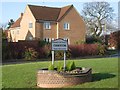
There are currently over 7.5m images from over14,400 individuals and you can help contribute to the project by visiting https://www.geograph.org.uk
Image Map
Images are licensed for reuse under creativecommons.org/licenses/by-sa/2.0
Notes
- Clicking on the map will re-center to the selected point.
- The higher the marker number, the further away the image location is from the centre of the postcode.
Image Listing (83 Images Found)
Images are licensed for reuse under creativecommons.org/licenses/by-sa/2.0
Image
Details
Distance
1
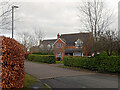
Pear Tree Way, Bilton
Pear Tree Way is a cul-de-sac leading off Lawford Lane; note the attractive block-paved roadway. The houses here date from the early 1990s.
Image: © Stephen McKay
Taken: 3 Feb 2021
0.03 miles
2
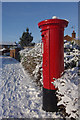
Postbox on Bilton Lane
Following a heavy snowfall, the clouds have cleared leaving bright sunshine to emphasise the red of the postbox against the white snow and blue sky.
Image: © Stephen McKay
Taken: 6 Jan 2010
0.03 miles
3
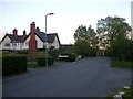
Bilton Lawford Lane
The original course of Lawford Lane rather than the one which runs through the Estate.The large house in the picture was surrounded by farmland until the development in the 1980s. This part of the Lane is now a no through route.
Image: © Ian Rob
Taken: 11 May 2010
0.07 miles
4
Path to Cawston Grange Estate
The path leads off Lawford Lane towards Whitefriars Drive on the Cawston Grange Estate. The houses to the left are on Dorset Close.
Image: © Stephen McKay
Taken: 3 Feb 2021
0.07 miles
5
Welcome to the Parish of Cawston
The sign has appeared recently on Calvestone Road; although essentially a modern housing estate, Cawston has its own parish council.
Image: © Stephen McKay
Taken: 17 Dec 2011
0.10 miles
6
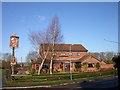
Rugby-Old Bilton
The Bear Public House nestling on the edge of a large residential area and the disused railway.The proposed Western Relief Road will probably be built close by, so it could pick up some passing trade.
Image: © Ian Rob
Taken: 22 Jan 2007
0.11 miles
7
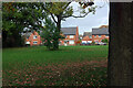
Open space on Cawston Grange Estate
A feature of this large modern housing estate on the edge of Rugby is the amount of open space with mature trees. This is looking across to houses off Great Orme Close.
Image: © Stephen McKay
Taken: 1 Nov 2020
0.11 miles
8
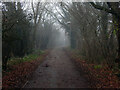
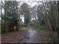
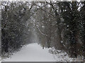
Bridleway to Cawston Grange
This is the same view as Image but at a different time of year - here the temperature is around freezing with fog in the air. But the same cat is approaching the photographer!
Image: © Stephen McKay
Taken: 31 Dec 2020
0.11 miles
9
Bridleway to Cawston Grange
Compare with Image and Image This time, however, the ginger cat has probably decided to stay in the warm. Who can blame it?
Image: © Stephen McKay
Taken: 8 Feb 2021
0.11 miles
10
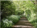
Bridleway to Cawston Grange
Cow parsley is flowering along the edges of this old bridleway which once made its way through open fields to the south of Bilton Lane but now passes through the modern Cawston Grange housing estate. It has acquired a hard surface and lamp posts but otherwise retains a rural feel at least along this stretch. Note the cat heading towards the photographer, quite unconcerned.
Image: © Stephen McKay
Taken: 2 May 2020
0.11 miles