IMAGES TAKEN NEAR TO
Monks Close, RUGBY, CV22 7FP
Introduction
This page details the photographs taken nearby to Monks Close, CV22 7FP by members of the Geograph project.
The Geograph project started in 2005 with the aim of publishing, organising and preserving representative images for every square kilometre of Great Britain, Ireland and the Isle of Man.

There are currently over 7.5m images from over14,400 individuals and you can help contribute to the project by visiting https://www.geograph.org.uk
Image Map
Images are licensed for reuse under creativecommons.org/licenses/by-sa/2.0
Notes
- Clicking on the map will re-center to the selected point.
- The higher the marker number, the further away the image location is from the centre of the postcode.
Image Listing (34 Images Found)
Images are licensed for reuse under creativecommons.org/licenses/by-sa/2.0
Image
Details
Distance
1
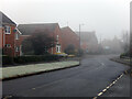
Calvestone Road, Cawston Grange Estate
Calvestone Road is one of the main thoroughfares through the estate - it incorporates a number of 'zig-zags', presumably to keep traffic speeds down. The Calvestone name appeared in the Domesday Book, eventually becoming Cawston. Freezing fog has enveloped the area and frost is still on the grass in this afternoon view.
Image: © Stephen McKay
Taken: 7 Jan 2021
0.04 miles
2
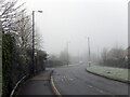
Calvestone Road, Cawston Grange Estate
Looking towards the junction with Cawston Grange Drive and Coventry Road in freezing fog conditions. The bus stop is the most southerly of three on Calvestone Road and is served by Stagecoach buses on route 4 to Rugby town centre.
Image: © Stephen McKay
Taken: 7 Jan 2021
0.04 miles
3
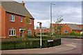
Cawston Grange Estate
Showing the junction of Turchil Road and Calvestone Road. This extensive new estate has been built on land that was previously Cawston Grange Farm to the south-west of Bilton.
Image: © Stephen McKay
Taken: 30 Sep 2007
0.05 miles
4
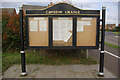
Cawston Grange Parish Notice Board
The newly-built Cawston Grange Estate has a newly-created parish council (Cawston Parish Council) to look after its affairs, the first meeting of which was held in May 2007. The council minutes are displayed on this notice board at the southern end of Calvestone Road.
Image: © Stephen McKay
Taken: 30 Sep 2007
0.07 miles
5
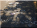
Thank you NHS
The Coronavirus pandemic has brought an outpouring of goodwill and support for the NHS. These chalk marks on a path on the Cawston Grange Estate are typical of many such tributes.
Image: © Stephen McKay
Taken: 28 May 2020
0.08 miles
6
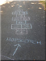
Hopscotch
Hopscotch is a children's game with ancient origins and numerous variations, requiring players to hop through a course typically marked out in chalk on a hard surface. It is evidently played on this path on the Cawston Grange Estate.
Image: © Stephen McKay
Taken: 28 May 2020
0.08 miles
7
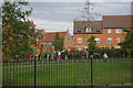
Cawston Grange Estate
Children play on the equipment provided on Turchil Road in the centre of this new estate.
Image: © Stephen McKay
Taken: 30 Sep 2007
0.09 miles
8
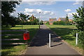
Bridleway through Cawston Grange Estate
The estate has covered the land once occupied by Cawston Grange Farm but the bridleway that once crossed this land can still be followed - more or less - now a tarmaced path.
Image: © Stephen McKay
Taken: 14 Jun 2009
0.10 miles
9
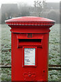
Postbox - Cawston Grange Estate
This facility is located on Calvestone Road. Although taken mid-afternoon, frost is still very much in evidence and the cobwebs on the postbox are covered in rime.
Image: © Stephen McKay
Taken: 7 Jan 2021
0.10 miles
10
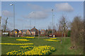
Daffodils at Cawston
Motorists approaching Rugby via the A4071 are treated to a splendid display of daffodils in March as they negotiate the roundabout that gives access to the new Cawston Grange Estate.
Image: © Stephen McKay
Taken: 22 Mar 2009
0.12 miles