IMAGES TAKEN NEAR TO
Dunchurch Road, RUGBY, CV22 6HW
Introduction
This page details the photographs taken nearby to Dunchurch Road, CV22 6HW by members of the Geograph project.
The Geograph project started in 2005 with the aim of publishing, organising and preserving representative images for every square kilometre of Great Britain, Ireland and the Isle of Man.

There are currently over 7.5m images from over14,400 individuals and you can help contribute to the project by visiting https://www.geograph.org.uk
Image Map
Images are licensed for reuse under creativecommons.org/licenses/by-sa/2.0
Notes
- Clicking on the map will re-center to the selected point.
- The higher the marker number, the further away the image location is from the centre of the postcode.
Image Listing (29 Images Found)
Images are licensed for reuse under creativecommons.org/licenses/by-sa/2.0
Image
Details
Distance
1
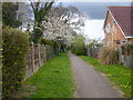
Rugby-Rokeby Estate
The bridleway on the western edge of the Estate.
Image: © Ian Rob
Taken: 25 Apr 2010
0.07 miles
2
Rokeby-Rosewood Avenue
Houses on Rokeby Estate looking from the bridleway,
Image: © Ian Rob
Taken: 25 Apr 2010
0.07 miles
4
Long Furlong, Hillside
The 'school' sign refers to Rokeby Primary School which is actually located on Anderson Avenue.
Image: © Stephen McKay
Taken: 12 Oct 2008
0.11 miles
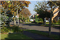
5
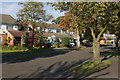
Long Furlong, Hillside
Leafy street connecting the Hillside and Rokeby estates.
Image: © Stephen McKay
Taken: 12 Oct 2008
0.11 miles
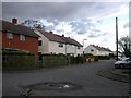
6
Rugby - Rokeby
Mid 20th Century Terraced Council Houses.
Image: © Ian Rob
Taken: 12 Dec 2005
0.12 miles
7
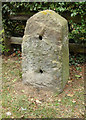
Old Milestone by the A426, Dunchurch Road, Rugby parish
Stone post (plate lost) by the A426, in parish of Rugby (Rugby District), Dunchurch Road, by No. 194, South of Milestone Drive, North of and almost opposite Sedlescombe Park, on grass verge, on West side of road. Erected by the Rugby to Lutterworth turnpike trust in the 19th century.
Inscription defaced for over a century.
Carved benchmark on lower face, partially buried.
Milestone Society National ID: WA_RGDN01
Image: © J & KS
Taken: 9 Jun 2002
0.13 miles
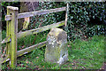
9
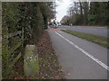
Rugby, milestone
Milestone on Dunchurch Road (A426). There are boltholes for a now disappeared plate; Victorian OS maps show it as defaced, rather than in WW2 as is normally the case. The legend probably would have given distances to Rugby of 1 mile, and Dunchurch 3.
Image: © Mike Faherty
Taken: 5 Mar 2010
0.13 miles
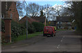
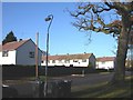
10
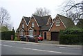
Rugby-Dunchurch Road
House close to the junction with Overslade Lane.
Image: © Ian Rob
Taken: 27 Mar 2011
0.15 miles