IMAGES TAKEN NEAR TO
Overslade Lane, RUGBY, CV22 6ED
Introduction
This page details the photographs taken nearby to Overslade Lane, CV22 6ED by members of the Geograph project.
The Geograph project started in 2005 with the aim of publishing, organising and preserving representative images for every square kilometre of Great Britain, Ireland and the Isle of Man.

There are currently over 7.5m images from over14,400 individuals and you can help contribute to the project by visiting https://www.geograph.org.uk
Image Map
Images are licensed for reuse under creativecommons.org/licenses/by-sa/2.0
Notes
- Clicking on the map will re-center to the selected point.
- The higher the marker number, the further away the image location is from the centre of the postcode.
Image Listing (48 Images Found)
Images are licensed for reuse under creativecommons.org/licenses/by-sa/2.0
Image
Details
Distance
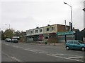
1
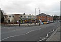
Rugby-Overslade Lane
Parade of shops built in the 1950s, at the junction with Everest Road.
Image: © Ian Rob
Taken: 11 Jan 2012
0.00 miles
2
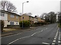
Rugby-Overslade Lane
Looking uphill from the junction with Everest Road.
Image: © Ian Rob
Taken: 6 Jan 2013
0.03 miles
3
Overslade-The Three Cranes Public House
This looks like the end of the road for another Public House.http://www.geograph.org.uk/photo/314348
Image: © Ian Rob
Taken: 5 Sep 2010
0.03 miles
4
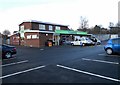
Rugby-New Cooperative Foodstore
On Overslade Lane making use of the former Three Cranes Public House which has been closed for a couple of years. http://www.geograph.org.uk/photo/314348 http://www.geograph.org.uk/photo/2054365
Image: © Ian Rob
Taken: 14 Dec 2011
0.04 miles
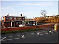
5
Rugby-Overslade Lane
Parade of shops on the corner of Everest Road
Image: © Ian Rob
Taken: 3 Oct 2007
0.05 miles
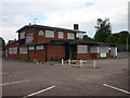
6
Rugby-Overslade
The Three Cranes Public House. Built in the 1950s to serve the expanding housing estates in the area, it is now fairly run down and the future is uncertain as Housing Developers have an eye on the land.
Image: © Ian Rob
Taken: 14 Jan 2007
0.05 miles
7
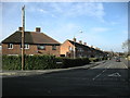
Rugby-Lytham Road
At the junction with Overslade Lane.
Image: © Ian Rob
Taken: 31 Jan 2009
0.05 miles
8
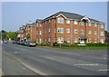
Rugby-Overslade Lane
Flats built on the site of a former Filling Station and Co-op Store.
Image: © Ian Rob
Taken: 20 Apr 2011
0.05 miles
9
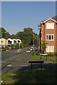
Overslade
Looking along Overslade Lane at its junction with Shakespeare Gardens. The modern block of flats on the right was built on the site of a former garage.
Image: © Stephen McKay
Taken: 12 Oct 2008
0.06 miles
10

Rugby-Shakespeare Gardens
New Flats built on the site of a Petrol Station.
Image: © Ian Rob
Taken: 31 Jan 2009
0.08 miles