IMAGES TAKEN NEAR TO
Wyken Croft, COVENTRY, CV2 1HQ
Introduction
This page details the photographs taken nearby to Wyken Croft, CV2 1HQ by members of the Geograph project.
The Geograph project started in 2005 with the aim of publishing, organising and preserving representative images for every square kilometre of Great Britain, Ireland and the Isle of Man.

There are currently over 7.5m images from over14,400 individuals and you can help contribute to the project by visiting https://www.geograph.org.uk
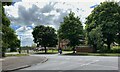
Image Map
Images are licensed for reuse under creativecommons.org/licenses/by-sa/2.0
Notes
- Clicking on the map will re-center to the selected point.
- The higher the marker number, the further away the image location is from the centre of the postcode.
Image Listing (12 Images Found)
Images are licensed for reuse under creativecommons.org/licenses/by-sa/2.0
Image
Details
Distance
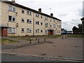
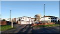
1
Flats on Widdecombe Close seen from Henley Road
These housing blocks form part of the Manor Farm estate, designed by Coventry City Architect Donald Gibson and his team: see Image
Image: © A J Paxton
Taken: 23 Mar 2024
0.08 miles
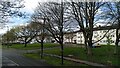
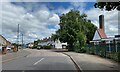
2
West on Henley Road, Coventry
On the left is the boundary to Manor Farmhouse Image The turning on the right is Broad Park Road Image
Image: © Robin Stott
Taken: 8 Jun 2022
0.10 miles
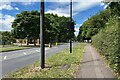
3
Henley Road, Henley Green, Coventry
Leafy Henley Road east of the junction with Broad Park Road. To the right is a block of 12 flats, Wyatt House.
Image: © Robin Stott
Taken: 8 Jun 2022
0.13 miles
4
Henley Green Flats
Typicalof the surrounding area, on Widdecombe Close off Henley Road.
Image: © Ian Rob
Taken: 26 Jul 2013
0.13 miles
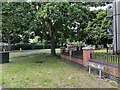
5
Broad Park Road meets Henley Road, Coventry
Across the road is Manor Farmhouse, a Grade II listed early 17th-century farmhouse https://historicengland.org.uk/listing/the-list/list-entry/1076611?section=official-list-entry OpenStreetMap shows it as Manor 'Farmyard' and garden but nothing about it can be found. It should not be confused with a restaurant in Earlsdon. Manor Farm gives its name to an entire housing estate in this area.
Image: © Robin Stott
Taken: 8 Jun 2022
0.15 miles
6

Manor Farmhouse, Henley Road, Coventry
It is a Grade II listed early 17th-century farmhouse https://historicengland.org.uk/listing/the-list/list-entry/1076611?section=official-list-entry It has given its name to an entire housing estate. It is clearly in use but its use is not known. Open Street Map shows it as Manor 'farmyard' and garden. Historic England shows it as Manor Farm Cottages.
Image: © Robin Stott
Taken: 8 Jun 2022
0.16 miles
7
North on Broad Park Road, Coventry
The turning on the right is Logan Road. The chimney probably belongs to Broad Park House. A report from 2019 explains that the Centre there provides short breaks for young disabled children https://www.coventrytelegraph.net/news/coventry-news/short-breaks-disabled-children-set-17333222
Image: © Robin Stott
Taken: 8 Jun 2022
0.16 miles
8
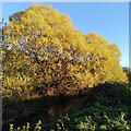
Willows by the River Sowe, Henley Green
They fit the description for crack willow, Salix fragilis, but willow species hybridise freely, according to the Woodland Trust site, with hybrid forms of crack willow and white willow, Salix alba, being especially common. It is mid-November and the leaves have turned a brilliant yellow.
Image: © A J Paxton
Taken: 11 Nov 2023
0.17 miles
9
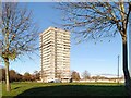
Caradoc Hall, Manor Farm Estate
Caradoc Hall on Caradoc Close is a 17 storey block of 129 homes, completed in 1969 by Truscon for the city of Coventry. Built as council housing, it was later used by Coventry University as student flats for about twenty years. More recently the building has been privately owned, with flats available for rent. See the Edinburgh University Tower Block site, which describes it as Manor Farm, Phase 3 https://www.towerblock.eca.ed.ac.uk/development/manor-farm-phase-iii . It is seen here from across the recreation ground by Hermes Crescent.
Image: © A J Paxton
Taken: 11 Nov 2023
0.19 miles
10
Hermes Crescent, Manor Farm, Coventry
Hermes Crescent consists of a single curving road branching off into small streets of houses on footpaths, with garages and road access on separate spurs. This is the Radburn model of housing estate design, developed in the USA from 1929, and widely used in Coventry council housing estates of the 1960s. Hermes Crescent dates from this period and formed part of Manor Farm Phase 3, together with the tower block on Caradoc Close, visible in the distance (see Image]).
The Crescent later fell on evil times, and pictures of boarded-up and burnt-out houses are not hard to find online. In the late 2010s it was 'regenerated' with extensive investment. Windows were replaced and insulating cladding fitted.
See Jeremy & Caroline Gould, Coventry: The Making of a modern city 1939-73, pp93-98, at the Historic England site https://historicengland.org.uk/images-books/publications/coventry-making-of-modern-city-1939-73/#:~:text=This%20book%20aims%20to%20inform,Coventry's%20remarkable%20post%2Dwar%20heritage.
Image: © A J Paxton
Taken: 11 Nov 2023
0.19 miles