IMAGES TAKEN NEAR TO
Petitor Crescent, COVENTRY, CV2 1EU
Introduction
This page details the photographs taken nearby to Petitor Crescent, CV2 1EU by members of the Geograph project.
The Geograph project started in 2005 with the aim of publishing, organising and preserving representative images for every square kilometre of Great Britain, Ireland and the Isle of Man.

There are currently over 7.5m images from over14,400 individuals and you can help contribute to the project by visiting https://www.geograph.org.uk
Image Map
Images are licensed for reuse under creativecommons.org/licenses/by-sa/2.0
Notes
- Clicking on the map will re-center to the selected point.
- The higher the marker number, the further away the image location is from the centre of the postcode.
Image Listing (19 Images Found)
Images are licensed for reuse under creativecommons.org/licenses/by-sa/2.0
Image
Details
Distance
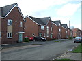
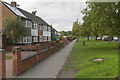
3
Deedmore Road
Modern housing stock on Deedmore Road, Coventry.
Image: © Peter Mackenzie
Taken: 27 Jul 2017
0.10 miles
4
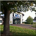
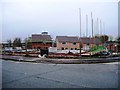
Moat House Leisure & Neighbourhood Centre, Wood End
The centre is a sports, leisure and community centre in Wood End, Coventry, which opened in 2009.
Image: © A J Paxton
Taken: 9 Oct 2022
0.11 miles
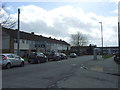
7
Henley Road
These houses are set well back from Henley Road which is the B4082. Along the road is an eclectic mix of houses.
Image: © Malcolm Neal
Taken: 29 Sep 2017
0.16 miles
8

Henley College
Further Education College on the North side of Coventry.
Image: © Kevin Croucher
Taken: 13 Jun 2005
0.18 miles
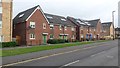
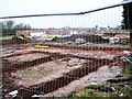
9
New houses and open space, Wood End, north Coventry
This replaces council housing built on farmland in the late 1950s, judging by old maps. There were terraces of houses and some small blocks of flats or maisonettes. Geograph has a few photographs of the original estate: Image and Image from 2010; and Image from 2012.
The road on the left is Melody Close. The River Sowe is off to the right: is some of this new development in the floodplain?
Image: © Robin Stott
Taken: 2 Oct 2016
0.19 miles
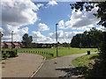
10
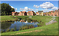
Surface water pond in open space for new housing, Wood End, north Coventry
This recent development replaces terraces of council houses built in the late 1950s. The view is north towards Melody Close, centre, and Lapworth Road, right. The house with the grey roof is detached; it has a garage. The rest are semi-detached though they appear detached at first glance. The River Sowe runs among the poplars, left.
Image: © Robin Stott
Taken: 2 Oct 2016
0.20 miles