IMAGES TAKEN NEAR TO
McKinnell Crescent, RUGBY, CV21 4AZ
Introduction
This page details the photographs taken nearby to McKinnell Crescent, CV21 4AZ by members of the Geograph project.
The Geograph project started in 2005 with the aim of publishing, organising and preserving representative images for every square kilometre of Great Britain, Ireland and the Isle of Man.

There are currently over 7.5m images from over14,400 individuals and you can help contribute to the project by visiting https://www.geograph.org.uk
Image Map (Loading...)


Getting Data...Please wait
Leaflet Map data © OpenStreetMap
Images are licensed for reuse under creativecommons.org/licenses/by-sa/2.0
Notes
- Clicking on the map will re-center to the selected point.
- The higher the marker number, the further away the image location is from the centre of the postcode.
Image Listing (12 Images Found)
Images are licensed for reuse under creativecommons.org/licenses/by-sa/2.0
Image
Details
Distance
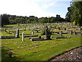
1
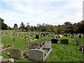
Rugby-Whinfield Cemetery
A view across the council owned cemetery.
Image: © Ian Rob
Taken: 7 Oct 2012
0.13 miles
2
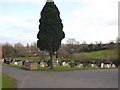
Rugby - Whinfield Cemetery
Looking east to Abbots Farm
Image: © Ian Rob
Taken: 15 Feb 2006
0.14 miles
3
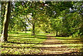
Bluebell Walk Abbots Farm Rugby
A pretty walk from Abbots Farm to Winfield Recreation ground
Image: © Anthony Warren
Taken: 29 Oct 2006
0.14 miles
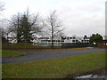
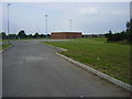
4
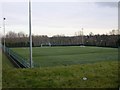
Rugby Town Football Club
New all weather training pitches next to the Football Ground.
Image: © Ian Rob
Taken: 30 Jan 2008
0.17 miles
5
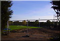
New practice ground for Rugby United
Reclaimed ground alongside railway, behind Rugby United Football Club
Image: © Anthony Warren
Taken: 29 Oct 2006
0.18 miles
6
Rugby-Whinfield Cemetery
Part of the largest burial ground in the town.
Image: © Ian Rob
Taken: 20 Sep 2009
0.18 miles
7
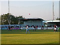
Rugby - Butlin Road
Home of Rugby Town F.C. (formerly Rugby Utd, most famously Valley Sports, Rugby) hosts a match between Coventry City and Arsenal Reserve teams.
Image: © Ian Rob
Taken: 16 Aug 2005
0.19 miles
8
Rugby-Eastlands Primary School
The replacement for the original building in St Peter's Road.
Image: © Ian Rob
Taken: 25 Nov 2007
0.21 miles
9
Rugby-Hart Field
The Lawrence Sheriff School Playing Field has resisted the developers threat and has flourished since Image
Image: © Ian Rob
Taken: 3 Jul 2011
0.21 miles
10
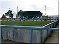
Rugby Town Football Club-Butlin Road
The Valley Sports Stand and Clubhouse.
Image: © Ian Rob
Taken: 30 Jan 2008
0.22 miles