IMAGES TAKEN NEAR TO
Newbold Road, RUGBY, CV21 2LQ
Introduction
This page details the photographs taken nearby to Newbold Road, CV21 2LQ by members of the Geograph project.
The Geograph project started in 2005 with the aim of publishing, organising and preserving representative images for every square kilometre of Great Britain, Ireland and the Isle of Man.

There are currently over 7.5m images from over14,400 individuals and you can help contribute to the project by visiting https://www.geograph.org.uk
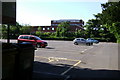
Image Map (Loading...)


Getting Data...Please wait
Leaflet Map data © OpenStreetMap
Images are licensed for reuse under creativecommons.org/licenses/by-sa/2.0
Notes
- Clicking on the map will re-center to the selected point.
- The higher the marker number, the further away the image location is from the centre of the postcode.
Image Listing (300 Images Found)
Images are licensed for reuse under creativecommons.org/licenses/by-sa/2.0
Image
Details
Distance
1
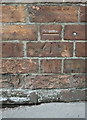
Benchmark on building at the south end of Newbold Road
The Ordnance Survey describe the building as 'outbuilding of municipal offices'. The cut mark benchmark is described on the Bench Mark Database at http://www.bench-marks.org.uk/bm57012
Image: © Roger Templeman
Taken: 17 Apr 2014
0.02 miles
2
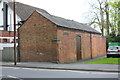
Brick building on the east side of Newbold Road
There is an OS benchmark Image about 2ft above pavement level in the middle of the road face of the building
Image: © Roger Templeman
Taken: 17 Apr 2014
0.03 miles
3
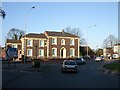
Rugby-Newbold Road
The Elms, offices on the corner of Oliver Street.
Image: © Ian Rob
Taken: 14 Jan 2007
0.03 miles
4
Rugby-Newbold Road
The Amalgamated Engineers Club is still going strong in spite of the decline in engineering in the town in the last 50 years.
Image: © Ian Rob
Taken: 16 Jul 2007
0.03 miles
5
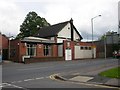
Rugby - Newbold Rd
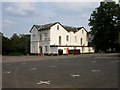
Police Station and Magistrates Court.
Image: © Ian Rob
Taken: 5 Mar 2006
0.03 miles
6
Rugby - Newbold Road
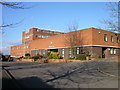
Council Offices. Car park is empty on a Sunday.
Image: © Ian Rob
Taken: 2 Jul 2006
0.03 miles
7
Rugby - Newbold Road
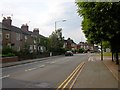
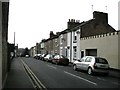
Terraced Housing near the Police Station.
Image: © Ian Rob
Taken: 2 Jul 2006
0.03 miles
8
Rugby-Hill Street
Near the junction with Newbold Road.
Image: © Ian Rob
Taken: 31 Jan 2009
0.03 miles
9
Rugby Police Station from the Town Hall car park
Image: © Robin Stott
Taken: 30 May 2009
0.03 miles
10
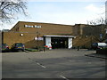
Rugby-The Benn Hall
Built in 1961 as part of the new Town Hall complex. It is the main venue in the Borough for live entertainment, exhibitions etc.
Image: © Ian Rob
Taken: 27 Jan 2008
0.05 miles