IMAGES TAKEN NEAR TO
Humphrey Close, RUGBY, CV21 1FQ
Introduction
This page details the photographs taken nearby to Humphrey Close, CV21 1FQ by members of the Geograph project.
The Geograph project started in 2005 with the aim of publishing, organising and preserving representative images for every square kilometre of Great Britain, Ireland and the Isle of Man.

There are currently over 7.5m images from over14,400 individuals and you can help contribute to the project by visiting https://www.geograph.org.uk
Image Map
Images are licensed for reuse under creativecommons.org/licenses/by-sa/2.0
Notes
- Clicking on the map will re-center to the selected point.
- The higher the marker number, the further away the image location is from the centre of the postcode.
Image Listing (116 Images Found)
Images are licensed for reuse under creativecommons.org/licenses/by-sa/2.0
Image
Details
Distance
1
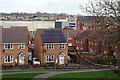
Development on the former GEC works site at Rugby
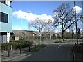
Looking down from the Viaduct Cycleway, the transformation of this part of Rugby can be appreciated. What was once part of the sprawling GEC (before that BTH) site is now used for housing and retail. The spine of this new neighbourhood is Technology Drive, running west-east from Leicester Road to Mill Road. Most of the land to the north is now a retail park, although there remains an industrial plant and there is some housing; to the south there is mostly housing as well as a further education college. In this view the housing in the foreground is on Humphrey Close, part of the St Modwen 'Edison Place' development, and Wickes DIY outlet can be seen in the background. Immediately above the Wickes sign the two towers visible are on the Junction 1 Retail park. In the distance is Brownsover housing estate.
Image: © Stephen McKay
Taken: 9 Mar 2021
0.02 miles
2
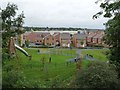
Houses and playground off Barnaby Road, Rugby
A new housing estate on the south bank of the River Avon. Seen from the former railway viaduct.
Image: © Christine Johnstone
Taken: 8 Sep 2017
0.02 miles
3

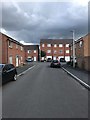
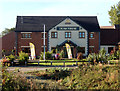
Butterfield Gardens, Rugby
Butterfield Gardens is a new housing estate currently being developed by Taylor Wimpey on former GEC works land to the south of Technology Drive. This is the junction between Technology Drive and Barnaby Road which leads into the development. The twee names builders love to give their developments are usually quickly forgotten once all the houses have been sold.
Image: © Stephen McKay
Taken: 23 Sep 2015
0.05 miles
4
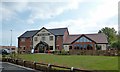
Rugby-Steam Turbine
New Public House built on the site of the former Alstom engineering factories.
Image: © Ian Rob
Taken: 4 May 2014
0.06 miles
6
Rugby-Leicester Road
The "Eleven Arches" looking from Yates Avenue.
Image: © Ian Rob
Taken: 4 Mar 2009
0.08 miles
7
The Steam Turbine, Rugby
This new pub, part of Greene King's Hungry Horse chain, occupies land once part of the vast GEC site. With a new housing estate, shopping mall and college nearby it seems to attract plenty of trade.
Image: © Stephen McKay
Taken: 23 Sep 2015
0.09 miles
8
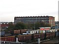
Rugby - Alstom
Part of the old GEC Mill Road Site (formerly AEI, BTH, Robinson Willans etc) which in the mid 20th Century employed approximately 10,000 people. Probably a few hundred now.
Image: © Ian Rob
Taken: 12 Nov 2005
0.09 miles
9
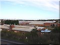
Rugby - Alstom Works
Part of the large site on which Sir Frank Whittle worked on the development of the Jet Engine.
Image: © Ian Rob
Taken: 12 Nov 2005
0.09 miles
10
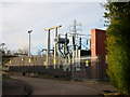
Rugby - Old Leicester Road
Electricity Sub-Station.
Image: © Ian Rob
Taken: 12 Nov 2005
0.09 miles