IMAGES TAKEN NEAR TO
Roman Way, RUGBY, CV21 1DB
Introduction
This page details the photographs taken nearby to Roman Way, CV21 1DB by members of the Geograph project.
The Geograph project started in 2005 with the aim of publishing, organising and preserving representative images for every square kilometre of Great Britain, Ireland and the Isle of Man.

There are currently over 7.5m images from over14,400 individuals and you can help contribute to the project by visiting https://www.geograph.org.uk
Image Map (Loading...)


Getting Data...Please wait
Leaflet Map data © OpenStreetMap
Images are licensed for reuse under creativecommons.org/licenses/by-sa/2.0
Notes
- Clicking on the map will re-center to the selected point.
- The higher the marker number, the further away the image location is from the centre of the postcode.
Image Listing (91 Images Found)
Images are licensed for reuse under creativecommons.org/licenses/by-sa/2.0
Image
Details
Distance
1
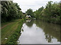
Oxford Canal Walk
Oxford Canal Walk at Rugby Wharf Arm Junction
Image: © Shaun Ferguson
Taken: 30 May 2016
0.05 miles
2
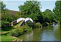
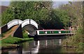
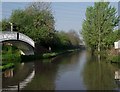
Oxford Canal east of Newbold on Avon, Warwickshire
The smart iron bridge carries the towpath across an arm on the left which is a remnant of the original canal built by Brindley and Simcock in the eighteenth century. This 300 metre arm is now used for moorings and by a boatyard.
The straightened and shortened canal (1829-1834) engineered by Cubitt is seen here, looking west towards Newbold and Coventry.
Image: © Roger D Kidd
Taken: 21 Aug 2013
0.05 miles
3
Oxford Canal east of Newbold on Avon, Warwickshire
The smart iron bridge carries the towpath across an arm on the left which is a remnant of the original canal built by Brindley and Simcock in the eighteenth century. This 300 metre arm is now used for moorings and by a boatyard.
The straightened and shortened canal (1829-1834) engineered by Cubitt is seen here, looking west towards Newbold and Coventry.
Image: © Roger D Kidd
Taken: 21 Aug 2013
0.05 miles
4
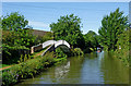
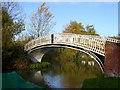
Oxford Canal aqueduct over road, Rugby
This is the second of the two aqueducts referred to in Image, this one carrying the canal over a minor road. The cast iron bridge at the entrance to the arm serving Rugby Wharf is more prominent.
Image: © Christopher Hall
Taken: 22 Apr 2011
0.05 miles
5
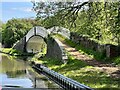
Oxford Canal entrance to arm to Rugby Wharf 1
A closer view of the entrance to the arm or branch serving Rugby Wharf. Photographs Image and Image show a progression towards this junction from the east. The boat is entering from the west; because of the angle of the junction it is easier for a boat from the east to go past the junction, turn and then approach from the west as Dabchick is. The cast iron bridge is one of those produced by the Horseley Ironworks circa 1828 in connection with the straightening of the canal described in Image
Image: © Christopher Hall
Taken: 22 Apr 2011
0.05 miles
6
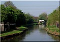
Rugby - Rugby Wharf
Entrance/Exit to Oxford Canal
Image: © Ian Rob
Taken: 12 Nov 2005
0.06 miles
7
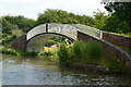
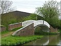
Rugby Arm Bridge
Grade II listed. Listing number 1249969 . Bridge carrying towpath across Rugby Wharf Arm. 1831-34 with slight C20 alterations. Single span, cambered deck made of prefabricated cast-iron plates. Haunches inscribed with name of manufacturer; HORSELEY IRON WORKS. Openwork parapet of moulded cast-iron railings forming a regular, attenuated diamond pattern. Solid brick abutments and trailing edge wing walls with brick copings.
Image: © Andrew Abbott
Taken: 3 May 2023
0.06 miles
8
Bridge over the entrance to the Rugby Wharf arm, Oxford Canal
Image: © David Martin
Taken: 16 Jul 2016
0.06 miles
9
Bridge over entry to Rugby Branch
The Rugby Branch off the Oxford Canal is a little offshoot, about 350yds (320m) long, which branches off southwestwards from the parent canal and culminates these days in a boatyard. Canal boats are usually moored along its length.
A graceful cast iron bridge spans its junction - it is numbered Bridge 53 according to the little plaque on the parapet, although there seems to be another Bridge 53 which spans the main canal a little further to the west.
Image: © Rob Farrow
Taken: 11 May 2013
0.06 miles
10
Oxford Canal entrance to arm to Rugby Wharf 2
A slightly closer view than Image Just beyond the sign on the right is a turning place or winding hole in canal parlance. When coming from the east, passing the junction and turning here makes entering the arm easier. This winding hole is a fragment of the pre 1820s alignment of the canal which turned north at this point and contoured round the valley crossed by the aqueduct shown in Image The old alignment just north of the present course is now covered by an industrial estate.
Image: © Christopher Hall
Taken: 22 Apr 2011
0.06 miles