IMAGES TAKEN NEAR TO
Electric Wharf, COVENTRY, CV1 4JL
Introduction
This page details the photographs taken nearby to Electric Wharf, CV1 4JL by members of the Geograph project.
The Geograph project started in 2005 with the aim of publishing, organising and preserving representative images for every square kilometre of Great Britain, Ireland and the Isle of Man.

There are currently over 7.5m images from over14,400 individuals and you can help contribute to the project by visiting https://www.geograph.org.uk
Image Map
Images are licensed for reuse under creativecommons.org/licenses/by-sa/2.0
Notes
- Clicking on the map will re-center to the selected point.
- The higher the marker number, the further away the image location is from the centre of the postcode.
Image Listing (133 Images Found)
Images are licensed for reuse under creativecommons.org/licenses/by-sa/2.0
Image
Details
Distance
1
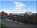
Electric Wharf, Coventry Canal
The industrial looking buildings round the bend of the canal are the former Coventry electricity generating plant, dating from the late 19th century. It has been refurbished in recent years and converted to a variety of live-work spaces and apartments, known collectively as Electric Wharf.
Image: © E Gammie
Taken: 12 May 2012
0.02 miles
2
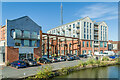
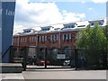
Electric Wharf
Part of Electric Wharf, the name given to the early 2000s commercial and residential redevelopment of the 1895 Sandy Lane Power Station, situated alongside the Coventry Canal.
Image: © Ian Capper
Taken: 23 Sep 2021
0.02 miles
3
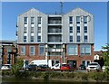
Boiler House, Electric Wharf
Residential units made to look like industrial buildings, a reversal of the normal trend. The lower part of the building includes commercial units, making use of some original structure, the upper stories comprise residential units, including student accommodation.
Image: © Alan Murray-Rust
Taken: 23 Sep 2021
0.02 miles
4
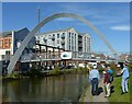
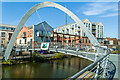
Checking out Electric Wharf
A group of Geograph members on a walk along the canal are being provided with information about the new Electric Wharf development. This comprises commercial and residential development of a former power station. The modern footbridge is a replacement for an earlier structure.
Image: © Alan Murray-Rust
Taken: 23 Sep 2021
0.03 miles
5
Turbine building Electric Wharf
The converted turbine house of Coventry's Victorian electric power station at Electric Wharf, viewed from the Sandy Lane side.
Image: © E Gammie
Taken: 12 May 2012
0.03 miles
6

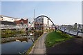
Electric Wharf footbridge
This footbridge, opened in 2006, connects the Electric Wharf development (the former Coventry power station) to the council depot on the opposite side of the Coventry Canal.
Image: © Hugh Craddock
Taken: 27 May 2008
0.03 miles
8
Electric Wharf Footbridge
Footbridge over the Coventry Canal built to link Electric Wharf, the name given to the early 2000s commercial and residential redevelopment of the 1895 Sandy Lane Power Station, with the canal towpath.
Image: © Ian Capper
Taken: 23 Sep 2021
0.03 miles
9
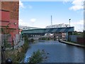
Coventry Canal by Electric Wharf
The footpath tiptoes round the edge the former Daimler power house towards Electric Wharf. Beyond the blue pipework enclosure is the footbridge to the towpath side.
Image: © E Gammie
Taken: 12 May 2012
0.03 miles