IMAGES TAKEN NEAR TO
Leicester Causeway, COVENTRY, CV1 4HL
Introduction
This page details the photographs taken nearby to Leicester Causeway, CV1 4HL by members of the Geograph project.
The Geograph project started in 2005 with the aim of publishing, organising and preserving representative images for every square kilometre of Great Britain, Ireland and the Isle of Man.

There are currently over 7.5m images from over14,400 individuals and you can help contribute to the project by visiting https://www.geograph.org.uk
Image Map (Loading...)


Getting Data...Please wait
Leaflet Map data © OpenStreetMap
Images are licensed for reuse under creativecommons.org/licenses/by-sa/2.0
Notes
- Clicking on the map will re-center to the selected point.
- The higher the marker number, the further away the image location is from the centre of the postcode.
Image Listing (93 Images Found)
Images are licensed for reuse under creativecommons.org/licenses/by-sa/2.0
Image
Details
Distance
1
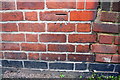
Benchmark on #1 Newland Road (Leicester Causeway face)
Ordnance Survey cut mark benchmark described on the Bench Mark Database at www.bench-marks.org.uk/bm112012
Image: © Luke Shaw
Taken: 4 Apr 2018
0.03 miles
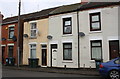
2
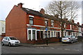
Newland Road houses at Leicester Causeway junction
There is an OS benchmark Image on the blank face of the nearest house at the junction with its abutting front side wall
Image: © Luke Shaw
Taken: 4 Apr 2018
0.03 miles
3
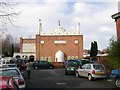
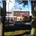
Coventry-Eagle Street Mosque
This small street is congested with cars belonging to people called to midday prayer.
Image: © Ian Rob
Taken: 7 Dec 2007
0.06 miles
4
Eagle Street Mosque, Coventry, looking towards George Street
Mosque in Foleshill, Coventry, at the junction of Eagle Street (blocked to road traffic here) and George Street.
Image: © A J Paxton
Taken: 14 Jun 2021
0.07 miles
5
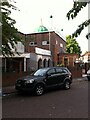
Mosque, Eagle Street, Coventry
The Noorul Islam Jamia Mosque is believed to be the oldest mosque in Coventry. It was registered for public worship in 1960 and opened the following year to serve a mainly Pakistani community, though the existing building may be more recent than this. https://www.british-history.ac.uk/vch/warks/vol8/pp396-397 Many mosques in Britain began as conversions of houses or other buildings and were in some cases later replaced by purpose-built structures. https://www.architectsjournal.co.uk/archive/a-history-of-mosques-in-britain
Image: © A J Paxton
Taken: 14 Jun 2021
0.07 miles
6
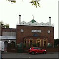
Noorul Islam Jamia Mosque, Coventry
Another, better, photo of the Noorul Islam Jamia Mosque, the oldest purpose-built mosque in Coventry (see Image]). It was registered for public worship in 1960 and opened the following year, serving a mainly Pakistani community. It is marked on the map with a cross by the Ordnance Survey, which largely ignored non-Christian religious sites for many years, but now uses the former church symbols with their crosses for all places of worship. Is this an advance?
Image: © A J Paxton
Taken: 1 Oct 2022
0.08 miles
7
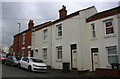
Houses on Eagle Street
In 1959 the Ordnance Survey verified a cut mark benchmark on #91: see www.bench-marks.org.uk/bm112010 - the mark has been lost to the rendering
Image: © Roger Templeman
Taken: 4 Apr 2018
0.09 miles
9
Leicester Causeway houses
The three right hand houses have cladding which has obscured an Ordnance Survey cut mark benchmark on #117 verified in 1959 - see www.bench-marks.org.uk/bm112013
Image: © Roger Templeman
Taken: 4 Apr 2018
0.10 miles
10
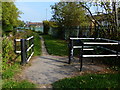
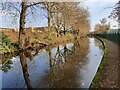
Gate along the Coventry Canal towpath
The houses on the right are along Leicester Causeway.
Image: © Mat Fascione
Taken: 11 Sep 2014
0.10 miles