
IMAGES TAKEN NEAR TO
Leicester Causeway, COVENTRY, CV1 4HH
Introduction
This page details the photographs taken nearby to Leicester Causeway, CV1 4HH by members of the Geograph project.
The Geograph project started in 2005 with the aim of publishing, organising and preserving representative images for every square kilometre of Great Britain, Ireland and the Isle of Man.

There are currently over 7.5m images from over14,400 individuals and you can help contribute to the project by visiting https://www.geograph.org.uk
Image Map
Images are licensed for reuse under creativecommons.org/licenses/by-sa/2.0
Notes
- Clicking on the map will re-center to the selected point.
- The higher the marker number, the further away the image location is from the centre of the postcode.
Image Listing (101 Images Found)
Images are licensed for reuse under creativecommons.org/licenses/by-sa/2.0
Image
Details
Distance
1
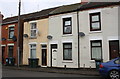
Leicester Causeway houses
The three right hand houses have cladding which has obscured an Ordnance Survey cut mark benchmark on #117 verified in 1959 - see www.bench-marks.org.uk/bm112013
Image: © Roger Templeman
Taken: 4 Apr 2018
0.03 miles
2
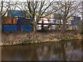
Container wall, Coventry Canal, opposite Leicester Causeway
This distinctive wall of containers, stacked three-high, forms the southern boundary of the metal recycling site that occupies part of the former Webster's brick and tile yard. The wall shields the houses beyond the canal from scrap metal processing noise.
Image: © A J Paxton
Taken: 3 Apr 2016
0.03 miles
3
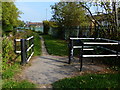
Gate along the Coventry Canal towpath
The houses on the right are along Leicester Causeway.
Image: © Mat Fascione
Taken: 11 Sep 2014
0.04 miles
4
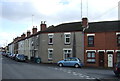
Terraced housing on George Street / Leicester Causeway
Image: © JThomas
Taken: 4 Mar 2017
0.05 miles
5
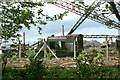
'Southam' in scrap yard, 1976
A 0-4-0 diesel shunter built by Hudswell Clarke as their D604 sits in a scrap yard by the Coventry Canal. The locomotive survived and was a feature of a pub at Southam for some while. The two chimneys are believed to be on the Courtaulds site, the central one near the junction of Guild and Pridmore Roads. Judging by the new state of the chain-link fence, the scrap yard has recently been extended over the site of former railway sidings. There is a suggestion of surviving rails this side of the fence at the left.
Image: © Robin Webster
Taken: 1 Jun 1976
0.06 miles
6
![A stroll along the Coventry Canal to Hawkesbury Junction [5]](https://s2.geograph.org.uk/geophotos/07/12/11/7121118_83ac9c70_120x120.jpg)
A stroll along the Coventry Canal to Hawkesbury Junction [5]
A pair of elegant local residents.
The narrow canal was built to connect the city of Coventry with the Trent & Mersey Canal, some 38 miles distant, to exploit the Warwickshire coalfields. Construction of the canal took 20 years before it was complete in 1769. The canal between the basin in Coventry and Hawkesbury junction was made a conservation area in 2012.
Image: © Michael Dibb
Taken: 23 Sep 2021
0.06 miles
7

Coventry : Coventry Canal
The Coventry Canal is a navigable narrow canal in the Midlands of England.
Image: © Lewis Clarke
Taken: 25 Sep 2021
0.08 miles

9

Stanton Bar and Grill
This was formerly the Stanton Social Club.
Image: © Keith Williams
Taken: 13 May 2015
0.09 miles
10
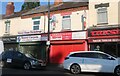
Shops on Stoney Stanton Road, Coventry
Image: © David Howard
Taken: 21 May 2023
0.09 miles